
20110717_MHW_Chiltern Hills Linear Walk– B-Walk
 When : 17th July 2011
Who : The Midland Hill Walkers – Walking Club
Where : Chiltern Hills – Mostly in Buckinghamshire & Oxfordshire, England
Maps used : OS. Landranger maps, no.175 Reading & Windsor and no.165 Aylesbury & Leighton Buzzard.
Start Point : SU806,917…. End Point : SU710,995
Distance : Approx 17.5 km (11 miles) (by measuring wheel + 1:50000 map)
Significant heights climbed : Difficult to say total heights as the route undulated up and down all day really ; at any one moment I can’t really remember any particularly difficult hills; longest climb probably about 360 feet.
Approx Route Map :-
Summary : B-Party walk with The Midland Hill Walkers ; Starting in Lane End then passing near Ditchfield and Hanover Hill before going through Fingest, Turville (Vicar of Dibley Village), Ibstone Common, Hailey Wood, Vicars Bottom, Lewknor, Under the M40 and finishing in Postcombe.
If you click on a pic’ it should launch as a larger image via my flickr photostream … or, if you don’t want to read my words and just look at my pic’s please use “this link” to my set of images – there are more pic’s there than shown below.
 As with all MHW [Midland Hill Walkers] walks, the coach left almost dead on 7:00 a.m. which had meant getting up very early to be out of the house by about 6:25 for the drive down the A45/A46 to Kenilworth.
Rather than go through all the blurb about car parks, timings, etc. please use this link to see my earlier posts about the MHW and the MHW own web-site.
Once out of Kenilworth, we headed off down the M40 and eventually called in at Beaconsfield Services for a 15-20 minute rest-stop; get boots on; get a coffee; grab a bite to eat; etc’. (The nutty pastry I bought with my coffee was very naughty but nice). Then it was back up the M-way for a short way before dropping further south past Marlow, crossing The Thames and then re-crossing the river again before turning right in Henley-on-Thames. This was a slower journey than it might have been due having to negotiate past competitors in a triathlon or other similar event. Once through Henley the A-party was dropped off (somewhere near Hambleden I think) and those of us in the B-team stayed on-board for a continuation of our mini magical mystery tour. We’d now almost done a full circle as we entered Marlow before taking a left onto the B482 for a longish climb up to Town End. I’m not sure if this settlement is a small town or a large village, but once disembarked we didn’t really see much of the place.
 Once assembled by the side of the B482, we immediately headed south passing a flint built church (Holy Trinity I think) and then swung around through a rather ram-shackled looking business yard with cranes and other bits of machinery. I’ve certainly walked through prettier places. One thing I did like here though was a Red Kite flying in amongst the tall cranes. From here things rapidly improved as we followed a path winding through semi-wooded undulating terrain, interspersed with pleasant farmland (some pasture-land and some planted up with ripening cereal crops). Somehow, even though the path was over 6-foot wide at one point I managed to get my legs stung on some stinging nettles – Most unpleasant! and it took another half-an-hour or so before I found some dock leaves to relieve the annoying painful itching …. The old wives/country remedy really does work though.


 Although grey and threatening, with rain in the air, I’d just about got away with no coat so far, but eventually I had to succumb and don my waterproofs as the light drizzle became quite steady fine rain, the sort that insidiously gets you drenched without really knowing when it happened. After some distance we arrived in the small village of Fingest, which consisted of a scattering of homes, a pub (The Chequers) and an ancient looking Church (St Batholomew) with an odd double roof atop its tower. After a short rest stop, we moved on and very soon found ourselves in the larger village of Turville.
Turville has at least two claims to fame in the world of film and TV. The first being the windmill (sat on the hillside above the village) was apparently used in the ever popular film, Chitty-Chitty-Bang-Bang; the second is the sit-com Vicar of Dibley was filmed in the village. The pretty village became another short stop, with us stood around having some lunch on the village green. It was just too damp to sit and really enjoy the surroundings. The weather certainly didn’t show the picture post-card like cottages off at their best but I did have a wander round trying to get some pic’s … I’ll let you decide if I did OK … My fave was one of a pink rose with the cottage window behind going out-of-focus.


We left Turville via a narrow pathway alongside a wood-clad building lined with deep pink hollyhocks before emerging onto a wide swathe of a path climbing up through a field of maize (still only a few inches tall). This marked the longest climb of  the day so far, but nothing untoward to cope with, even though it did steepen for a short section as we climbed above the vibrant greens in the valley below. Several Red Kites joined us, effortlessly moving through the grey skies above and then drifting across the valley below us. These raptors really have become a success story since they were re-introduced to The Chilterns some years ago and the numbers we saw during the day certainly seem to back this up.
 After some more pleasant walking through patchy woodland (especially as the rain had stopped now) we reached Ibstone Common and glory be, the sun came out!… actually casting some shadows and the open grassland afforded a perfect place for our main lunch stop of the day. Once sated a couple of us wandered over to a large and isolated standing stone, to my eyes looking rather lonely, but none-the-less stood proudly upright.
Once we were all packed up and raring to go again, we headed into the woodland bordering the common and then once through to the other side, swinging north to meet a track leading up to Wellground Farm. From here we branched left, rising up  through Hailey Wood. I know it’s a bit of a cliché, but I do like the dappled light that sunshine makes as it filters through deciduous woodland; it’s just one of those things that just can’t help but raise the spirits. We got quite strung out on the climb through the woods which meant a regroup at a salient spot. This was quite important, as our route took a left turn to drop quite quickly and it could have been very easy to lose any back-markers if they hadn’t seen us take the side path. The drop was quite steep compared to the walk done so far, to level out out in a small valley at Vicars Bottom and a very nice country residence. The leaders 1:25000 map shows Vicars Bottom as Lower Vicars Farm which might be more P.C. but doesn’t have the same humour and charm as the name on my 1:50000 scale map.
 After skirting the attractive property we picked up a drive way rising up to a minor road (near Upper Vicars Farm). An embarrassing and very annoying squeak then decided to manifest itself every time I put my right boot down. I was told it could be heard several yards away … to compensate, I got my head down and pushed on and soon found myself on our leaders shoulder, upon which he said he was happy for me to go ahead of him, just to stop at the junction with a road.
This turned out to be the last proper climb of the day and I quite enjoyed the short blast to the top of the rise where we all regrouped once again. This point marked a change in the terrain, as, after crossing the road and a small scrubby field, a superb  vista opened up in front of us. We were now stood at the top of The Chilterns Scarp Slope; the Oxfordshire plain spread out below us with the M40 cutting a swathe through the fields as a sinuous line into the distance. Although we couldn’t actually see it, we were positioned just a matter of yards to the south of the very recognisable Stokenchurch Gap, where the motorway rises up onto the top of the Chilterns on its way to London. The unnatural gorge through the chalk is also sometimes known as the Aston Rowan Cuttting or Aston Hill Cutting.
 The descent was easy and we were soon walking across the flat farmland we’d been looking down upon a few minutes earlier. The walking was made even easier by picking up a long access road and after crossing the B4009 into the village of Lewknor.
We were again treated to the sight of several Red Kites flying silhouetted above us.
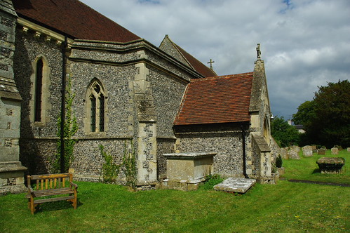
 After a little road walking through the village, we were soon leaving the village, closely passing the attractive St. Margaret’s Church en-route to pick up a wide verge down the side of a very large cereal crop field. We were getting ever closer to the M40 and eventually had to cross under the motorway via a rather unattractive utilitarian underpass. This was now the last leg of the route and all we needed to do was cross a couple of fields, the crop was now broad beans – quite a tall scruffy crop, but at least we had some tractor lines to follow.
The walk ended at the “England’s Rose” pub at Postcombe on the A40. Apparently it’s named after Lady/Princess Di.  We were made very welcome, although it did feel a little of an oddity especially as they had no draught bitter on tap, I think they’d simply run out, so bottles of beer had to be bought. And then it was homeward bound, back up the M40 to Kenilworth including a well earned snooze for many of us ….
And that’s the end of this diary post, I hope you enjoyed my scribblings and pics …. If you’d like to comment on my diary or any of my pic’s please feel welcome.
T.T.F.N. Gary
