20180326_Cawston to Bilton Green & Back (after knee op’s)
When : 26th March 2018
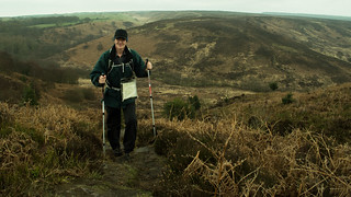
Who : Just me (oh, and my camera and my new metal knees)
Where : Cawston/Bilton to the south west of Rugby Town, Warwickshire

Start and End Point : SP470,735 Trussell Way.
Distance : Approx 2.6 miles (4.2 km)
Significant heights : None to speak of.
Maps : There was no point in using a map as this was only a local wander, but, if you want to know, the 1:25,000 OS Explorer map that covers the area is Map No.222 Rugby & Daventry.
Summary : A very little walk in some rare 2018 spring sunshine to stretch my legs after recent knee surgery.
If you click on a pic’, it should launch as a larger image on my photostream on Flickr … a right click should give you the option of launching in a separate window/page.
 If you’ve read my previous post [Coombe Abbey Walk] you’ll know that I’ve recently had surgery giving me two, brand new, half knee replacements (done at the same time), and as part of my recuperation I’ve been trying to get some walking miles “under my belt”, or really “in my legs” trying to get back to some kind of fitness.
Well, the day after the “Coombe Walk”, I mentioned on FB this comment :-
“After my 2.3 miler yesterday, thought a wander down to Mosaic Coffee shop for brunch would be good – So, today my muscles felt like I’d done a 17 miler the day before – Strewth I’ve got some work to do to get back to reasonable fitness levels !!!!!!!!”.
 That little walk to the lovely little coffee shop, on the 23rd March, was only ¾ mile, but was probably needed, just to loosen the muscles up a tad. So, to keep up the effort, I decided another local walk was needed and this time I decided a little further would be in order.
Now, the weather of late winter and early spring 2018 had been particularly poor, with periods of snow and ice making going outside a tad hazardous, especially hobbling around with two crutches, and even when there was no snow and ice, it was cold and wet and grey and miserable; Pretty much trapping me indoors and limiting me to just wandering around a supermarket’s aisles – Not very inspiring at the best of times. So, when the weather finally 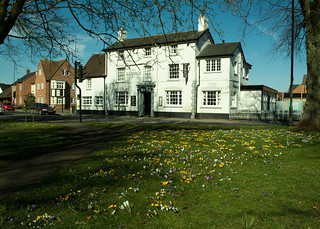 relented, and a drop of sunshine decided to make an appearance, I decided a “stroll” down to the local village of Bilton would be a good thing to try.
I made Bilton Green the focal point of the walk, as it was covered in its annual display of crocuses and I thought trying to get a few photos would be a good motivator. It’s also a perfectly pleasant walk through the Cawston Grange estate, especially the green spaces that have been provided as part of the housing development. The area is becoming more mature now, trees and shrubs reaching a decent size, softening the hard edges of roads and houses.
 As several of my past walks diaries have used Trussell Way as a start point, I’ll once again describe starting on Trussell Way on the outskirts of the estate. Until recently this was a “dead-end”, with direct access onto the perimeter path and there was roadside parking that wouldn’t have infringed too much on local residents. However, the dead-end has recently been removed; the road now pushing further on into what was farmland and is now being built on by Mssrs William Davis enlarging the housing estate further south. There are currently restrictions on the house builders parking here, but I guess the restrictions will only be relatively temporary.
To describe getting to the start-point:-
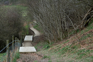
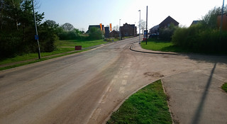
Leave Cawston Grange Drive at an island, into Trussell Way, pass the side roads of Cave Close (on the right) and Durrell Drive (on the left), and then soon after, Trussell Way crosses a grassy area, just before it starts to rise again into the new housing being built.

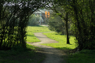 The grassy strip includes the current perimeter cinder path, which I picked up gently rising in a south easterly direction, to pass through a tall hedge line, the small trees forming an inviting arch over the path, to emerge into a narrower strip of greenery with the established houses of Durrell Drive on my left and new housing going up behind trees/hedging/shrubbery on my right. Continuing on, the path flattens out and much of the existing housing is shielded by shrubs (red stemmed cornus predominantly) maintaining a rural feel, although I guess that will wane as
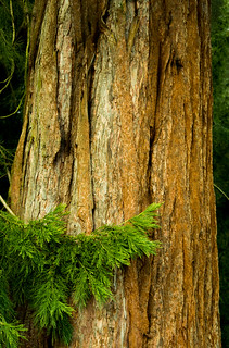
  the new housing goes up and becomes lived in. I particularly like the shapes some conifer trees made here against the pale blue sky in the weak sunshine.


At the top of the path, after passing through another hedge line, a tarmac path (walking and cycleway) is reached in front of a stand of large trees and undergrowth separating the path from the B4642 Coventry Road (was the A4071 until a few years ago).
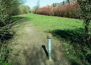 Incidentally, the anti-vehicle post here was adorned with a woolly hat, I don’t know if it had been lost or if someone had taken pity on the metal post and decided it needed warming up during the recent chilly weather.
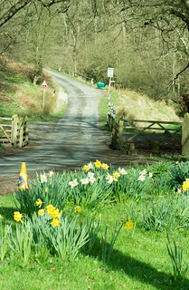
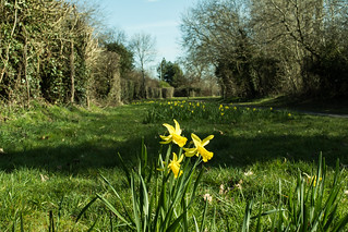
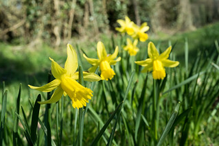
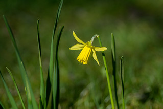
Anyway, that’s beside the point really, because, I was to turn left here, but immediately stopped to take a few photos of some cheery daffodils/narcissi that come up here every year. It wasn’t the best display I’ve seen since they were planted, but I guess that might be down to the comings and goings of all the building works happening nearby, or maybe just down to the awful winter weather.
 Getting low enough to take the pic’s wasn’t terribly easy as my knees didn’t want to bend very far, and I certainly couldn’t kneel down (far too painful !), so it was a case of spreading my feet as far as I dared, bending over as far as possible, using the live view rotatable screen on my camera and at full stretch trying to keep the camera as still as I could. Being 6’4”plus, I must have looked like some kind of strange giraffe trying to take a drink in that position. I must admit most pics failed due to camera shake, but some I think look Okish.
 Once I’d managed to stand upright again and just a few paces further on, the combined path/cycleway reaches Cawston Grange Drive, which I crossed straight over to a “Welcome to the Parish of CAWSTON” brick-built planter
  and sign. To my mind an attractive way to say hello to the estate. However, I have heard a dissenting voice from residents of what could be described as “old Cawston” down the Coventry Road, who feel the sign should be further down towards the Brickhouse Spinney area and so include them in the welcoming of visitors; either that or it was suggested the sign ought to read welcome to Cawston Grange Estate. Looking at the parish boundary map, they do have a teeny-weeny bit of a point. Whatever the politics, personally I have no problems with the wording or the sighting of the sign, which is backed by a small stand of trees and shrubs, an attractive way to welcome visitors to the area.
 Anyway, I passed to the left of the signage and the stand of trees to pick up a wide tarmac footpath heading across a green with a large Christmas Tree to my right [that gets lit up in the winter each year], and a line of individual trees just to the left, including some quite mature cherry trees that were just waiting for warmer times to burst into flower. They look great when they do, albeit for a very short time, and the cherries taste good later in the year too. The tarmac path follows the line of an official right of way (a bridle track) which dates way, way back, to long before the idea of a housing estate here had probably ever been dreamt up.
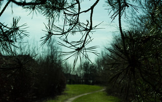
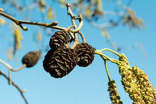
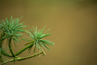
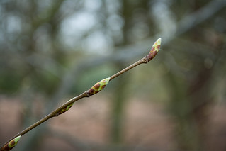
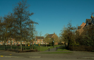 After a short stretch down the tarmac bridle way, I reached and crossed Turchil Road passing a small fenced off play area designed for younger kids. This is a roughly triangular space surrounded by grass and trees softening the hard edges of the adjacent houses. All in all, a quite attractive estate green space. I particularly liked some catkins and cones hanging from a tree against the perfect early spring sky-blue sky; even local to home it’s worth looking for the little details that bring a little happiness – after-all, who doesn’t like spring catkins?
 The next bit I’m gonna skip over quite quickly as I continued on, on the tarmac path, reaching Gerard Road where I then turned right, passed the small group of shops (A Chippy, Chinese Take-Away, Hair and Beauty Salon and a local CO-OP store), reaching and then crossing directly over Calvestone Road, across a small green with a few
  trees to pick up another tarmac path that soon emerges into a wide open “sports” field.
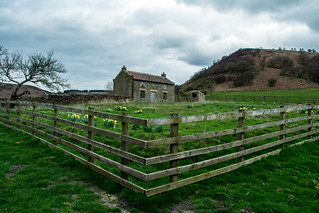
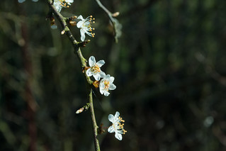
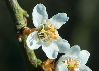
I say sports field but in reality, there’s only one “goal post” for anyone to use, but it is a large expanse of flat grassland. The path follows the edge of the field with a boundary fence separating the public space from Bilton School’s sports/playing fields along with a series of trees and large shrub hedging just coming into flower – I think probably Blackthorn (Sloe), the pretty slightly off-white petalled flowers with yellow centres indicating warmer times were on their way, hopefully a good spring being just around the corner.

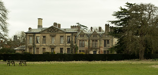
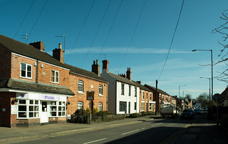 Again, trying to stay a little brief, the path emerges onto the Coventry Road (B4642) where I crossed to the opposite side, turned left and walked into Bilton Village where the road continues as the B4642 but under the name of Main Street. Bilton itself is to me an unassuming place with a pleasant mix of housing (from old to brand spanking new), a selection of shops (including a Tesco Express and a CO-OP), some small businesses, a doctors surgery, Two Pubs (The Black Horse and The George), a butchers, a specialist cheese shop, several take-away outlets, four churches (Bilton Evangelical, Bilton Methodist, Sacred Heart RC, all within shouting distance of each other and at the opposite end of the village is St. Mark’s CofE not reached on this walk). There’s also a small (and free at the time of writing) car park just behind the Tesco store.
 The other place I haven’t mentioned above, is Mosaic Coffee Shop/Café, a lovely friendly place that I would have called in to for a coffee or maybe a hot chocolate, but unfortunately, it’s closed on Mondays, so wasn’t available today.
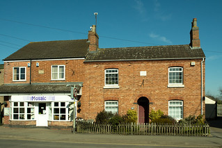
Mosaic’s building has a plaque saying it’s called Ewarts House built 1890 and next door is Rose Cottage built 1885. If only the red brick walls could speak of all the changes they’ve seen over the last 130 years or so.
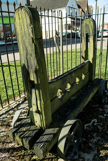
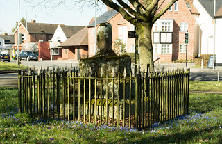
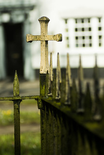
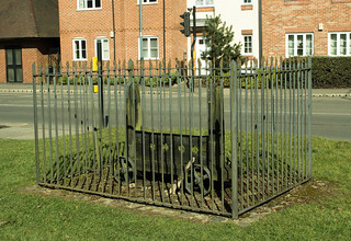 Talking of history, outside the CO-OP is a set of wheeled stocks kept safely behind a set of be-spiked metal railings and then a short distance away in the middle of the Triangular Green (bounded by roads) is the old Butter Cross. I say cross, but the top half is now long gone leaving just the heavy tiered stone base and bottom stump of the cross itself. The monument is also kept safe inside metal railings also adorned with spikes and with crosses at each corner. I wonder how many people even notice it’s there as they negotiate this busy junction of roads controlled by traffic lights and overlooked by the white-washed frontage of The George pub across the road.


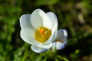
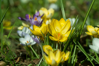
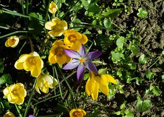
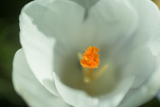
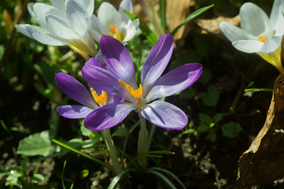
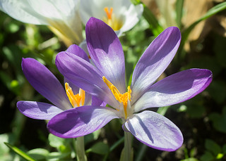
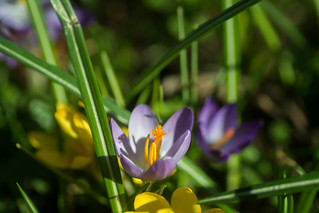
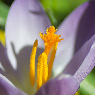
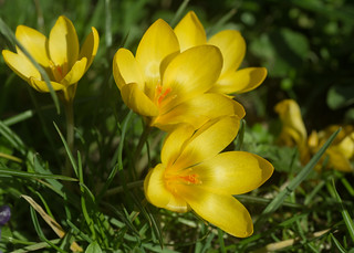
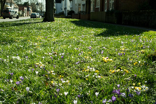 It was this area of “The Green” that was my motivation for the walk, as each spring the ground is briefly bedecked in the whites, purples and yellows of crocuses.
It really is quite special, especially with the sun shining and it was well worth pushing my knees to reach here for a closer lingering look, rather than a passing glance from the car window.
Anyway,I shot off far too many pic’s (again!) …. there really isn’t a shot to take that couldn’t be described as a cliché in one way or another, but hey, I don’t care.
 Crocuses are cheery, happy little flowers and I enjoyed trying to capture their character as best I could, and I make no apologies for the images contained here.
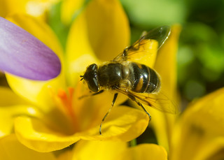
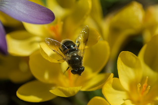
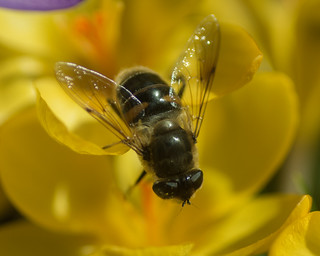
I particularly enjoyed watching a few bees attracted to the flowers, braving the chill in the air despite the early season sunshine being quite pleasant, especially compared to some of the sub-zero temperatures we‘d been experiencing not long before.

 My knees were feeling the strain somewhat, so I took time out to sit on a bench just inside the nearby Assheton Recreation Ground for a bit of rest and recuperation before thinking about the walk home. I must admit it made me feel just a little sad that a slow, flat, easy walk for little more than a mile had resulted in having to sit and rest because of pain and tiredness. I guess having to overcome self-doubt about whether it was right to have such surgery is just as important as working the physical side of building muscles and stretching tendons.
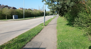
 Sorry, that got a little downbeat there, but no, I picked myself up, brushed myself down and gave myself a bit of a talking to, re-motivating myself and re-cajoled my knees to straighten-up as much as possible again and carry me back down Main Street, re-passing all the previously mentioned places en-route, and re-crossing the Coventry Road back into the large sports field effectively separating Cawston from Bilton. Instead of heading back up the boundary to Bilton School, I turned left following the tarmac path running parallel to the Coventry Road separated by a mature hedge.
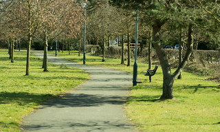
 The path here is bounded by a line of trees which will in time become an avenue to walk down. Also here several stands of trees/shrub planting are now growing to be quite sizeable and break up the view across the large field. I like this path – in fact I like living on our housing estate, and it’s not only the physical surroundings, it’s the people too. Invariably most people I pass on these paths will nod, smile or say hello – I guess it’s called community.
Anyway, at the end of the path, it was back into streets, where I followed Kalfs Close left into Gold Avenue and left onto Calvestone Road crossing over to meet Cawston Grange Drive back at the stand of silver birch trees and the brick “welcome to Cawston” planter/sign.

 It was now back to re-following my earlier steps, crossing Cawston Grange Drive, passing the daffs (more pic’s taken), then right onto the perimeter path down to Trussell Way and the start point and then back to home.

 Not quite 2½ miles but I was pretty much cream-crackered, but really very satisfied that I’d managed it, although the amount of post exercise discomfort was yet to kick in. But that’s why they supply prescription strength drugs! …. The walk also had the knock-on effect of giving me something to occupy my mind whilst in enforced rest – namely reviewing, deleting and editing my pic’s.
Well, I hope you enjoyed my scribblings …. If you’d like to comment on my diary or any of my pic’s please feel welcome. I’d love to hear from you.
T.T.F.N. Gary.
PS. I’ve now finished and published the above diary in July 2018, some 4-months after I did the walk ….. and I’m now back at work and, amongst other walks, I’ve completed a 12 miler up in the White Peak, and a nearly 14-miler locally. Knees seem to be holding up. When I find time I’ll have to write them up/publish as well.

 My site, as I add my diary posts, will build a retrospective look back at country walks I’ve done, in what I hope is an informative and entertaining way for you to share.
 The boring stuff (perhaps) :-
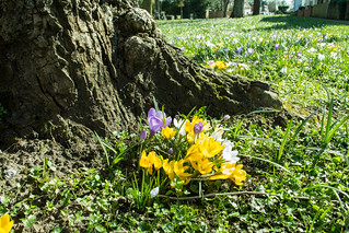


 Well, as noted in


![20090828-99_Sanderling [or similar]_Boggle Hole Beach](https://farm2.staticflickr.com/1324/4733756639_cb61d098d6_n.jpg)