20090418-am _Mam Tor to Lose Hill Ridge Walk and Castleton
When : 18th April 2009
Who : A group of young people on an outdoor activities weekend including me helping out with adult leadership and supervision
Where : Hope Valley, Derbyshire, Peak District, England.
Maps : 1:25000 OS Explorer Map OL1 – The Peak District-Dark Peak Area.
 Start Point : 124,832
End Point : 162, 825
Approx Distance : 5.4 miles, 8.6 km
Heights up : 1020 ft (about 310 m)
Heights down : 1750 ft (about 533m)
Parking : There’s a car park just to the south of Rushup Edge/Mam Tor off the Castleton to Chapel-en-le-Frith Road.
Summary :- Mam Tor, Hollins Cross, Back Tor, Lose Hill (Ward’s Piece), Castleton, Pindale Farm Camp Site (near Hope Cement Works).
 The massed ensemble of adults and young people (or if you like trainee adults) gathered in the car park just outside the bunk barn after breakfast. Hanging around for everyone and everything to be ready allowed a little time to take in the views across the valley, affording a good proportion of where the morning walk would go; including the flanks of Lose Hill and the ridge from Mam Tor.
Somehow, we morphed from one big group into three separate entities …One set disappeared on mountain bikes (heading up towards Pin Dale) to do some off road cycling; another group departed in a mini-bus for Bamford Rocks for some climbing and the last group (with me) piled into another mini-bus to head off for our nice little morning hill walk. We’d all arranged to meet back at the camp site around about lunch time to swap activities.

 After driving down to the Village of Hope (leaving the cement works chimney behind), we turned left, passed through Castleton (on the A6187) and then headed up the spectacular gorge of Winnats Pass. It was so impressive that my daughter Katie says she can’t even remember it some 6-months later!, so much for youth … still, I’ve always liked geography and limestone gorges kind of do it for me. It’s not a long drive, but it’s well worth doing, just for its own sake, just remember to use low gears on the steep bits!. At the top of the pass we turned a sharp right and then a left heading towards Chapel-en-le-Frith. Just a few hundred yards along here on the right is a large car-park which is where we started the walk from.
 After parking, we set off, heading uphill to meet a minor road where it passes through a gap in the hills heading towards Edale. Almost immediately we took a path to the right onto a wide made-up path to climb a set of steps up onto Mam Tor. Straight away even before gaining much height views started to open up. Off to the west is Rushup Edge which has a superb path running along it’s crest, but that wasn’t for this weekend, although it did look most inviting … perhaps one for another day.
 To the north the views into Edale are superb. The minor road descending the hillside leads the eye down into the valley from where the broad expanse of Kinder Scout looms above, the start of The Dark Peak Proper. Probably our most famous long distance path, The Pennine Way, starts in Edale Village to head up onto the plateau spread out in all its glory way off in front of us.


 It’s a short sharp little climb up the steps to the cobbled top of Mam Tor, the summit marked with a trig’ point and it certainly made one or two of the kids puff a bit. However, the views are fantastic in all directions and everyone was in high spirits despite the chilly and quite strong breeze. The sun however was desperately trying to break through the cloud cover, spreading a hazy light all over the valley below … a promise of a good day ahead.
Leaving the top of Mam Tor, we took the very obvious flag-stoned path dropping away along the crest of the ridge heading eastwards. In terms of map reading you can’t get much easier than this, which is brill’ as it allows all your time for just walking, chatting and taking in the views. I love this ridge, with Edale and The Dark Peak to the north; the ridge stretching ahead to the east; the Hope Valley and The White Peak to the south and behind to the west, the sweep of the path back up to Mam Tor. The east face of “The Mother Hill” has slipped away into the valley in a series of massive landslips. So much so that the old road from Castleton is now totally defunct, now superseded by the Winnats Pass road we’d used earlier in the morning.

The ridge itself is a couple of miles or so long and the path rolls along the crest in a series of drops and rises. After Mam Tor, the first staging point reached is Hollins Cross. This is a low point on the ridge and several paths converge here from both The Hope and Edale valleys. From here the path takes a bit of a climb where it’s called Barker Bank following the line of a wall that’s seen better days.
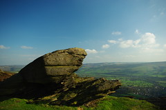
Upon reaching the top of Barker Bank, the next little climb comes into view … Back Tor, and Craig’s Tree which I’ll explain in a mo’. There’s a small drop before rising gently towards Back Tor to eventually climb quite steeply to the top of the crag jutting out above the Edale Valley.


By now there were quite a few people about, heading both in our and opposite directions and ascending routes up the hillside from the valleys on either side.
A few years ago, I did this section of the walk with my family, where my son Craig (he was maybe 5 or 6 years old) taking a shine to the lone tree near the top decided to RUN up the hill to beat the rest of us to the tree. To this day, this little lone conifer has been known to us as Craig’s Tree. There are now two sets of walkers that now know this name too … perhaps in years to come it will come into common use and no-one will know it’s origins. I think our little naming is quite apt, as Craig’s name has its roots in meaning Crag or Rock … and that’s exactly what it’s perched on top of.

 The top of Back Tor is a super place to sit for a while, maybe to take some refreshments, catch your breath again and maybe drink in the views, especially over Edale. After a short break and a regroup we set off again still on the ridge top, still with brilliant views and happily chatting amongst ourselves and offering cheery hello’s to fellow walkers. It wasn’t long before we reached the summit of Lose Hill (also known as Ward’s Piece). A look back showed virtually the entire walk done so far. Although the clouds had broken up quite considerably, it was still quite breezy and there was a definite chill on the wind, so we all hunkered down in a hollow for lunch and a chat.
  Just above us set into the rocks is a brass plaque pretty much hidden away from the main route over the top, and certainly not visible from the direction post thingy on the broad summit. I’ve been on this hill numerous times and I can’t recall ever seeing this plaque before …. I especially like the sentiment at the end “A RAMBLER MADE IS A MAN IMPROVED”.
 Lose Hill really marks the end of the ridge and it’s rough slopes drop in all directions. Our route descended to the south to pick up a series of paths and farm tracks through much more gentle farmland in the Hope Valley, There were stands of trees, walls, fences, streams, stiles and gates, side paths and buildings to pass … quite pretty, but I needed to concentrate much more on the map reading now as we zigged and zagged across towards Castleton. We’d obviously not worked the younger members of the group hard enough as they were still rather boisterous at one point trying to knock us oldies off some stepping stones into a small stream we had to cross.

 Once into the village, we had to cross the main road and we joined the throng of other visitors to walk up and past the church in the village centre. This really is a very, very, popular place to visit and understandably so. I’ve stayed at the youth hostel here several times as it is a superb base for walking. There are a smattering of shops (albeit mostly touristy) and a number of pubs, all in all a perfectly charming peak village.

We soon reached a small triangular green with a stone cross and a tall tree. From here we had a section of road walking, climbing out of the village heading eastwards, towards Hope, on a minor road. The lane soon levelled out and became more rural, leaving the outskirts of Castleton behind. The views to the north had opened up again, the full ridge from Mam Tor to Lose Hill forming the horizon showing the majority of the walk done so far. The valley bottom had a spring vibrancy in the sun; greens of various hues bursting out from their winter slumbers …. I do like spring! I think it’s probably my favourite season.


As the lane dropped ahead of us, the chimney of Hope Cement Works came into view marking our destination … our camp site nestled underneath the ugly but somehow quite compelling structure.
 And that was it …. Our group had completed the walk, I hope with a degree of satisfaction, their next activity was to be the off road cycling.
Just as an aside, if you wanted to make this into a circular walk, it’s quite easy as there are various paths from Castleton that can be taken to climb back up to the car park near Mam Tor; including the superb Cave Dale, The old broken road and another that passes in front of the famous show caves associated with Castleton.
If you’re wondering, we got the mini-bus back by two of the adult leaders driving up in the car, so that the bus could be driven back down again … it didn’t take long before we were all ready for the afternoon activities.
Hope you enjoed my scribblings, Gary.
….
Thanks to Kev747 for the use of his pic’s of Winnats pass from his photostream on the flickr photo hosting website.
….
Other walks of this weekend =
https://tothehills.wordpress.com/2009/11/22/20090418_win-hill-ladybower-bamford-rocks-walk/
https://tothehills.wordpress.com/2009/11/23/20090419-am_mam-tor-to-lose-hill-ridge-walk-and-castleton-reprise/
https://tothehills.wordpress.com/2009/11/26/20090417-19_peak-district-weekend-an-overview/
Next walk after these 3 outings = 20090508_Park Wood-Bluebells Walk With Dad.

 The week-end was to consist of three activities: – Off Road Cycling, Rock Climbing and a bit of Hill Walking.
 As it happened, I ended up doing the same walk twice, with the two youngest groups on the Sat and Sun mornings. However, the older group had enough leaders amongst themselves and they decided they didn’t need my services, nor that of another adult helper …. so, we two extraneous chaps set off to do a walk just by ourselves on the Saturday afternoon. I could have tried to combine the three walks, as it could be written as a single linear route … however I’ve decided to keep it simple and write-up the walks just as I did them, as three separate stand alone posts. Each of the walks could be used as the basis of a circular quite easily.
 Walk-2 … 20090418-Afternoon Walk – Win Hill.
 Walk-3 … 20090419-Morning Walk – The Mam Tor Ridge.