20080619 : Fleetwith Pike – Haystacks Walk
When : 19 June 2008
Who : Just me
Where : Lake District – England
Approx distance : 15 km 9-1/2 miles
Significant height : 875 m (mostly up, but some downs included)
Parking : Car Parks in village or side of road above chapel.
Public Transport : Yes but limited times
Route Summary : Buttermere Village ; Buttermere Lake south shore ; Gatesgarth ; Fleetwith Edge ; Fleetwith Pike ; Dubs Bottom ; Haystacks ; Scarth Gap ; Buttermere Lake north shore.
This is the second of four walks of my short break of 4-days in the North West area of the Lake District. My post “20080618-21 Lake District – 4 Day Beak” gives a bit of background, but it’s not essential to what follows here. This walk was by far the longest and most strenuous of the 4 days.

I parked by the side of the road, just above the chapel on the outskirts of Buttermere Village (there’s no charge here, but space is limited which wasn’t a problem for me as I was up and about quite early). A small area is set aside for visitors to the chapel, so please respect this if you use this area for parking. There is parking in the village as well but I’d image there’d be a charge here.
This walk has a superb variety of terrain and pretty much encapsulates almost everything you could want from a Lakeland walk, including :- Lakeside woods; tumbling becks; a steep climb on an airy ridge; working quarries; fell top tarns and craggy hummocks to explore. All the time there are superb views and there’s even a tunnel the footpath negotiates.
I started off in good dry conditions which was pretty amazing given the sweeping rain that had blasted up the valley the evening before. From the chapel I dropped into the village of Buttermere and crossed the flat meadows between Buttermere Lake and Crummock Water, taking the more easterly of the two bridle tracks down to the shoreline of Buttermere Lake.


I crossed the footbridge over Buttermere Dubs as it flows out of the lake (on its way to Crummock Water) and immediately took time out to have a look at the spectacular torrent of Sourmilk Gill, swollen from the previous day’s rain. After a short while, I headed off on the well made path through Burtness wood. I decided to ignore the path that closely follows the shoreline, instead choosing the wide well made path set back and a little higher in the woods. This is a great start to a walk, pretty much level on good paths allowing legs to be stretched out and it was just what I needed to walk off a bit of stiffness from the previous day’s exertions.
 The views across the lake to the surrounding fells framed by the trees are super, especially with a little brightness occasionally glinting off the crags and slopes. I wasn’t moving as easily or as quickly as maybe I’d have liked, but this gave the opportunity to soak up the Lakeland atmosphere. Despite a covering of low cloud I could see the top of Fleetwith Pike, the highest point of the walk ahead.
 After a while, the path leaves Burtness Wood onto open fell and soon after, crosses the tumbling Comb Beck cascading down from Burtness Comb under the imposing heights of the High Stile ridge. (From across the other side of the lake, Comb Beck and its sister Sourmilk Gill, mentioned earlier, appear as thin ribbons of white against the dark fell side. It’s quite surprising how much noise these cascades make especially after heavy rain).
 At the southernmost corner of Buttermere Lake, I ignored the path angling up towards Scarth Gap. Instead, staying low, I soon turned left to cross Peggy’s Bridge and the flat meadowland to Gatesgarth Farm to emerge out onto the B5289 Honister Pass road. Turing right along the road, the route starts its first and by far the hardest climb of the day.
There is charged parking at Gatesgarth Farm, and as the route passes through the farm (twice the way I walked it) this would allow the walk to be shortened by approx. 3-1/2 to 4 miles, but this would entail missing out on the considerable charms of the lakeside paths.
Leaving the road after a very short while, the path branches right onto the fell side and soon begins its steep climb up Fleetwith Edge and soon after the path passes close to a memorial cross set just below one of the lower crags. You’ll need to make a small detour to get a close up view and read the inscription. I didn’t get close enough to be able to read it myself, but according to various other web-sites, the memorial commemorates Fanny Mercer who was accidentally killed here in 1887. I suppose there’s a lesson for us some 121 years later that care is needed on these rugged fells.

There followed a pretty much unrelenting steep climb up the imposing Fleetwith Edge for the best part of a mile and although the path was easy to follow, I certainly slowed considerably. However, because of its fantastic position at the head of the valley and the steepness of ascent, superb views quickly opened up all around and my frequent breather stops facilitated being able to turn around and take in the full spectacle as it unfurled.


My only concern was the strong blustery wind that kept gusting across the ridge. At times I felt quite vulnerable, my 6′-4″ frame actually being a disadvantage for a change and I had to crouch down low to the ground a couple of times whilst I waited for the worst of the buffeting to subside. Oddly the higher I went, the less windy it became and as I found my climbing legs, the final reaches of the ascent were nicely achieved.
 The familiar feelings on reaching the summit flooded over me and I drank in the views all around. The most obvious pull on the eyes was the classic view down the Buttermere and Crummock Water valley, stretched out towards the coast. However, the mountains all about fought for my attention, the heavy moody clouds on the tops adding a drama to the scene.
 In particular swirls of cloud drifted and spiralled up and out from the depths of Gatesgarth Dale immediately below (on its way to the Honister Hause Pass). It was very atmospheric with the steep flanks of Hindscarth and Dale Head behind, appearing to be little more than a stones throw away. It was a superb backdrop to the ever changing patterns in the ethereal mists.

[Please click on the link below to see a 360 degree panorama from the summit of Fleetwith Pike]
https://tothehills.wordpress.com/2008/10/03/fleetwith-pike-video/
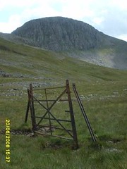
 With the highest point of the walk accomplished, I set off again, staying as high as possible following the path to Black Star crags, above Honister Crag, and then dropped quite quickly towards the Honister Quarries. Before descending too far, I turned south, taking care as I crossed some of the quarry workings and roadways and I swung more westerly for the drop to Dubs Quarry. The slate workings are not what you’d call pretty but added a certain interest and variety to the walk, especially with the heavy mine vehicles trundling back and forth.


The clouds were becoming more ominous now and I increased my pace hoping to get to Dubs Quarry Mountaineering Hut before the impending squall hit me. Despite breaking into a bit of a jog (boots and rucksack don’t lend themselves to this really) I never-the-less failed in my quest by about 50 yards and I reached the hut’s porch-way half soaked.
Trying the doorway, it opened and I stepped in taking refuge for about ½ an hour dripping and steaming as I dried out. I made this a convenient lunch stop watching as other walkers trudged by in the downpour, I assume them not knowing about the huts basic but dry charms. If you do need to use Dubs Hut, please treat it with respect, leave nothing behind and close the door securely as you leave.


As the rain eased, and now fully “cagged-up”, I set off again finding the path down to where Dubs Bottom drops off steeply into Warnscale Bottom. There were a couple of little streams to cross near to Little Round How, which I did quite easily despite some walkers ahead of me seemingly finding it problematic to find a convenient crossing place. New views opened up down towards Buttermere again, framed perfectly by the crags.
The rugged but obvious path (now rising) passed near to the northern tip of Blackbeck Tarn, but as the rain had started up again I chose not to make the detour to take a closer look. However, despite the current downpour, the clouds had lifted somewhat and the silhouettes of Green Gable and Great Gable looked superb across the tarn and beyond the nearby hummocky crags.


Soon afterwards after a little more height gained and now heading generally westwards I reached Innominate Tarn. This is a lovely welcome to the charms of Haystacks. Made famous by a certain Alfred Wainwright where he wrote “All I ask for, at the end, is a last long resting place by the side of Innominate Tarn, on Haystacks….And if you should get a bit of grit in your boot as you are crossing Haystacks in the years to come, please treat it with respect. It might be me”: AW 1966 [ passage borrowed from : http://www.wainwright.org.uk/ ]
The main path skirts just to the north of the tarn, with its 3 little islands in a row, but as it’s such a lovely spot and the rain had eased almost to a stop, I decided to spend some time exploring the craggy hummocks and hollows as I made a small circuit around what is really little more than a large pool.

Rejoining the main path I quickly rose to the summits at the top of Haystacks. I say summits deliberately as there are several cairns and craggy tops all of which look higher than each other depending on where you happen to be standing. I’ve got to admit: I do like Haystacks, it’s got a certain magic about it, in its nooks and crannies, tarns and pools, crags and hollows the whole fell top is interesting to explore and the views all around are superb – Even if like today most of the higher tops were shrouded in cloud.
[Please click on the link below to see a 360 degree panorama from the summit area of Haystacks]
https://tothehills.wordpress.com/2008/10/03/fleetwith-pike-video/
From the multiple summits, it was a steep rocky descent and quite hard work on the legs and concentration, but it didn’t last long before I reached the Scarth Gap Path and quite a major cross roads: to the left, the path drops into Ennerdale; straight on climbs to Seat and onwards to the High Crag / High Stile / Red Pike ridge; to the right, the path heads off towards Buttermere. This last option was my route for the day and I followed the rugged path, dropping quite quickly and it became gentler and easier as it lost its height. From the path I could see a good proportion of the route I’d completed, Fleetwith Edge’s profile in particular in fine view.
[Please click on the link below to see a 360 degree panorama from the Scarth Gap Path as it descends across Buttermere Fell]
https://tothehills.wordpress.com/2008/10/03/fleetwith-pike-video/

Looking out over Buttermere Lake I could see the far bank where the last leg of the walk would bring the day to a very satisfying conclusion … Still that was to come, I pressed on and some blue sky started breaking through the cloud cover, welcoming me down and across Buttermere Fell … it’s amazing how a little brightness can bring a lift to your step. Upon reaching Peggy’s bridge for the second time in the day, I fairly bounced along the meadow track to Gatesgarth Farm as I reprised the morning’s outward route.
Upon reaching the B5289 instead of turning right as before, I headed left along the road until I reached the lakeside, where upon I picked up the permissive path along the north shore. The route all the way back to Buttermere village was quite straightforward and is a lovely stroll in its own right and although I thought tired legs would take the edge off the enjoyment, the views were stunning especially as the Sun finally decided to break through properly and the waters began to sparkle.


A highlight of this north shore permissive path is a short tunnel hewn through where Dalegarth’s grounds abruptly fall into the lake as a rocky crag.


From here onwards the feel is much more gentrified enhanced by the evening Sun warming me for the first time in the day, still better late than never!


Despite the at times very inclement weather I’d had a good days walking, although physically taxing in places it felt just like old times revisited … I’ll not leave it anyway near as long again, before I come back for more.
Quite a long diary entry this one, for which I’m not too sorry, the feelings of getting a good Lake District walk in again are too vivid to skip over quickly this time.
Oh and just to finish, I got a superb sunset from just across the road from the hostel, and it wasn’t the first time that had happened, what a simply wonderful place!


Despite the length of prose, I hope you enjoyed my scribblings ….
Next walk = 20080620, Honister Hause to Great Gable and Return : link = https://tothehills.wordpress.com/2008/09/16/20080620_great-gable/
End


 Not that being at Honister Hause Y.H. was a problem, in fact I really like the hostel with it’s superb setting, good food and friendly staff & fellow guests (oh and no stairs to climb to the dorm’!). All in all, it felt homely and to my mind just like a traditional youth hostel should …. No, the problem was deciding what kind of walk suited me, especially as I hadn’t moved particularly quickly on the previous two days. My preference would be to:-


 Whilst on a family holiday, I generally try to get at least one walk under my belt, whether this is with my family or on my own. Our summer hol’s this year was on The Lizard on the South coast of Cornwall. Amazingly neither my wife nor I had ever holidayed this far south on Mainland England before, so everything was new to us. I had walked sections of the South West Coast Path (SWCP) before, in Dorset, South & North Devon and Somerset, and I’d had a week-end walking around the Fowey area (pronounced Foy I believe), but had not been around the Lizard area before.


 On this last section I had anticipated walking into a stiff breeze and perhaps even some squally showers, but as it happened, the weather was now pretty much settled and a totally unexpected problem had now manifested itself …. the setting sun, low on the horizon was blinding my vision ahead. I had to walk with hands held above my brow in order to see where I was going.
 Descending to the sea wall at the East end of the East beach (Dogs allowed here by the way), I decided to drop down onto the beach to walk along on the firmer sand left by the ebbing tide. Easily fording the shallow outwash where a stream crossed the beach, I passed the low rocky promontory that separates the East and West beaches (no dogs allowed on the West beach).


