20120909_Kenilworth Castle Photographic Outing
When : 9th September 2012
Who : Me + My course tutor + some other students
 Where : Kenilworth Castle, Kenilworth, Warwickshire, England
Maps used : 1:25000 Outdoor leisure map no.211 (Coventry and Warwick)
Start and End Point : SP280,721 … Main Car Park for the castle
Distance : Not far … Approx 2½ to 3 miles ….ish.
Significant heights : None to speak of … apart from steps up and down the ramparts, and a couple of spiral staircases, but you don’t need to do them if you don’t want to.
Click on a pic’ and it should launch as a larger image on my flickr photostream.
Use this link for a larger set of images without the words
This diary details a day out, but not really a country walk as-such, but there are half a dozen rights of ways radiating out from the castle area and these can be linked to make various length circular walks, which I’ve done several times in the past. However, today was specifically allocated for photography, so, I just touched on a couple of the public footpaths, just to see if I could get a good view point for some pictures of the outside of the castle.
It had been prearranged to meet at noon in the main car-park just off Castle Road (B4103) , but I decided to arrive early (about 10:50 as it happens) to give me a little time to walk around the outside of the castle, figuring that once everyone else had arrived we’d probably go straight inside. I also thought having the sun a little lower in the sky might give longer shadows and so give better depth to my pic’s; in reality I think I’d have had to be there at least another hour earlier as there wasn’t significantly much difference in the quality of light between 11:00 and 12:00.
When I arrived, the sky was a lovely blue with just a hint of thin wispy white clouds, and I was hopeful my new circular polarizing filter (a birthday prezzie) would come into its own, so I headed off to the pay-and-display machine with a bit of a spring in  my step. The charge (£2.00) is refundable upon entrance to the castle (£8.00 – in 2012) and I’d say for a car-park charge, £2.00 was reasonable should you just wish to go for a countryside walk from here.
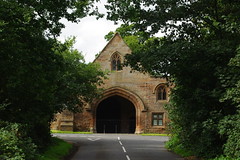
Anyway, as I was taking my first picture (from near one end of the car park), a passing gent’ (out walking his dog), made a tongue-in-cheek quip that it must have been the first time ANYONE had EVER taken that PARTICULAR view … and YES, I suppose it could be described as a clichéd shot, but hey, it immediately sets the scene – The Castle completely dominates the view and I defy anyone with a camera not to take this snap.
To start with, I crossed the track in front of me, dropping slightly to go through a kissing gate (near a notice board) and then turning left I picked up a path heading almost due west along the side of a little wood. On my OS map, this path is marked as  part of a long distance route and marked as “Midland Link”. It seems to make a connection between “The Centenary Way” here in Kenilworth and “The Heart of England Way” further to the west. (The “A Coventry Way” also passes quite close, so this link path could be used to connect in various ways). Anyway I headed maybe a couple of hundred yards or so along here to get some pic’s from where the path makes a joggle into a tree lined sunken track. This allowed me to frame the castle with the lower branches and leaves of the trees and the shadows on the ground … again this could be described as a bit of a cliché, but a time honoured technique that nearly always works.
I then turned back on myself, headed back to the kissing gate, rose up to the car park area again and strolled down to the ticket office positioned at the end of a raised  causeway. Once I’d negotiated past the lady trying to get me to take out yearly membership of “English Heritage”, [the non-profit making guardians of the castle], I bought my entrance ticket and continued down the causeway towards the castle itself … but …just before Mortimer’s Tower I dropped down the bank on my left and set off around the outside of the castle walls in a clockwise direction. At times I stayed low, slightly away from
  the walls, on a narrow dirt path, at other times I got up close to the walls to see the detail in the stonework, including some attractive natural weathering and human graffiti carvings from many years ago.
After a short time, the path reaches a lane (Purlieu Lane) and I made my way onto this and turned left for a very short distance, before turning off to the right on another footpath rising up a grassy field towards some ruined farm buildings. My idea was to reach the top of the rise, turn around and get a shot of the castle from this slightly elevated position. I was hopeful of a decent shot but not particularly expectant as the sun was high and I was facing mostly into the brightness.
The results were as  feared :- disappointing!, being rather flat and lack-lustre even after a little editing …. I’ve only kept one image from here, just to post up with this diary and give an indication of the view.
After a couple of minutes, I gave up and headed back down to and along Purlieu lane, back into the field next to the castle and then immediately swung left around an attractive cottage to follow a narrow well worn path by the side of the castle walls again (still heading around clockwise) and emerged into a small car park by the side of Castle Road (B4103). Across the other side of the road is a very attractive row of cottages set back from the road across a small grassy area known as Castle Green. I was much happier with the couple of photo’s I took here.

 Dropping to the far end of the mini-car park I picked up another dirt track (opposite The Queen and Castle Pub/Restaurant) to once again follow the outer perimeter walls in a clockwise direction, only this time very close to the walls. I really like this little corner, looking across the road junction to Castle Hill through a little stand of pine trees. The pubs, cafes (including The Clarendon Arms and Harringtons on The Hill) and cottages here are absolutely pristine looking, very picturesque. Normally we just pass by here without really seeing, but having camera in hand it kind of forces you to look more closely and it is lovely here.
A look at my watch told me it was very nearly 12 o’clock, and therefore time to meet my fellow photographers, so I picked up my pace, followed the path over a small stream (that floods the nearby road to make a sizable ford at times), along the bottom of the bank that carries the causeway and then up to the main car-park. This only took a couple of minutes and I was soon chatting to my friends and we all moved off towards the ticket office for them to pay their entrance fees.
It was at this point I offered around some blueberry muffins as a late 50th birthday treat, which could be considered a bit of a mistake, as the photo course tutor (David Harding) pretty much constantly ribbed me about “getting old” for most of the afternoon – Thanks David !!!!
 Once everyone had paid and run the gauntlet of the “will you become a member today” lady, all six of us headed off into the castle grounds or to be more accurate, into The Inner Court. The scale of the buildings seemed different inside compared to outside, as the walls segregate you from the wider landscape and so the tall towers, even in their ruinous state, are really quite imposing. Anyway, we went our separate ways and I set off at a slow pace pretty much on a clockwise route, but zig-zagging back and forth into and out of the various buildings/ruins looking for interesting subjects to “snap”. The mix of brick and sandstone, grassy banks and trees, sunshine, blue sky, clouds, silhouettes, deep shadows and bright highlights gave plenty of scope for photo’s.


I’m sure we probably all ended up with a mix of wide views and intimate close ups. I thought I was being quite inventive concentrating on some of the carved graffiti in the stone work (hundreds of years old in some cases), only for one of our group to show me he’d been doing precisely the same thing ! …. is there a new or unique idea left in the world ? – I doubt it; we all just keep re-inventing the wheel.

In places, I liked the way the stone had weathered over the years, eating away at the once dressed surfaces creating interesting curves and ridges, almost organic shapes. I’d also carried my tripod around with me, and I actually got to use it in a couple of places in some of the darker areas, as I couldn’t hold the camera still enough for the aperture size vs exposure times I was experimenting with.


I also quite liked the graphic angles of bright light and deep shadows from some of the windows and doorways and in one place, I spent quite some time trying to get a sunburst effect through one of the stone windows.


The busiest place in the castle seemed to be where a series of wooden staircases rise up one of the buildings affording some super views out over the local farmland (used to be a huge shallow lake or mere in the castle’s hey-day) and also across the inner Court and over to the recreated Elizabethan knot garden with its geometric planting beds, pergolas, obelisks and central fountain sculpture. Somehow without actually arranging it we’d slowly regrouped and we ended up dropping down a set of stone steps into the garden for a closer look.

As we reached the centre of the garden, David kind of set an informal task to photograph the white marble fountain (no flowing water today though) … I think his thoughts were that there’d be a problem with overexposure and loss of detail of the raised “carved” freezes. Well I’ve seen one of David’s pic’s (on flickr) and he solved the problem by shooting into the sun and making a feature of the fountain’s silhouette. I took a different tack, attempting to use narrow depth of field and close up detail at a steep angle to the carvings. How a single subject can be seen in different ways !


I think by now I was getting pretty much all photo’d out and upon entering Leicester’s Gatehouse a big sign said no photography …. This part of the castle isn’t in ruins at-all, and the rooms are open to view. The top floor has an exhibition exploring the relationship of Queen Elizabeth 1 and her favourite courtier Robert  Dudley Earl of Leicester. The final photo I took was of the outside of Leicester’s Gatehouse before we headed off to the cafe, for a drink (posh bottle of dandelion and burdock for me) and a chat outside in the sun.
And, that was that, we all headed back to our cars and I headed off to Coventry for a family meal at The Wing Wah (an all you can eat buffet style Chinese restaurant) at the junction of Broad Lane and the A45.
The end …. I hope you enjoyed my scribblings and photo’s …. If you’d like to comment on my diary or any of my pic’s please feel welcome.
T.T.F.N. Gary
 End Point : 285,723 [Abbey Fields, Kenilworth]