20100103_Brinklow-Wolston-Coombe Abbey Circular Walk (2)

20100103_Brinklow-Wolston-Coombe Abbey Circular Walk

Section-2 … Wolston to Brinklow via Coombe Abbey

When : 3rd January 2010

Who : Me and for part of the walk my Son Craig

Where : Brinklow-Wolston-Brandon-Coombe Abbey, Warwickshire.


Maps : Virtually all on 1:25000 O.S. Explorer Map No.222 Rugby & Daventry plus a tiny bit on the neighbouring Explorer Map No.221 covering Coventry.

Start + End Point : Grid Ref. 436,795 

Approx Distance : Full walk = 10.5 miles (17 km) …. This Section = 7 miles (11.5 km) 

Heights : Some very gentle rises, I’m hard pressed to note anything of any real significance – I guess about 25m rise between The Avon at Brandon up to Coventry Stadium is the longest “climb” but it’s really not enough to be of concern. 

Parking : I parked on the street in Brinklow … but as a circular you could start anywhere, the most obvious other places being in Wolston or at Coombe Abbey Country Park (charges apply at the park-but you are off road). 

Public Transport : Bus services do run through the villages and to Coombe.

20100103_Brinklow-Wolston-Coombe Abbey Circular WalkSummary : A circular walk midway between Coventry and Rugby taking in the villages of Brinklow, Bretford, Wolston and Brandon and the historic Coombe Abbey. 

This is the continuation from the 1st leg of this walk …. and now it was only me walking, my son having been picked up by Mum as he’d had enough by the time we reached Wolston. Once I’d waved them off, I was freed up to stretch my legs and being able to ignore the frozen puddles (you’ll know the significance of this if you’ve read my earlier diary post) I started to move rather more quickly now. As I was on very familiar ground I didn’t need to do any map reading for quite some way … The route headed down Wolston Main Street, passed the Memorial Cross, alongside a small pasture taking in the view over to St. Margaret’s Church and re-crossed The River Avon via a metal footbridge next to the single lane stone bridge. 


Once over the footbridge (after pausing to admire a couple of swans on the river) the path swung right, passing the earthworks of Brandon Castle before reaching and passing under the substantial arches of a rather impressive viaduct. This carries the West Coast Main Line Railway between Rugby and Coventry. A combination of The River Avon and the railway effectively keep Wolston and Brandon as separate identities, albeit Brandon being much smaller in size. 

Once on the Brandon side of the viaduct, I managing to ignore the charms of the nearby Royal Oak Pub and headed through the village to pick up the A428 at the end of Avondale Road. The route was to turn left, heading up the main road, passing some attractive cottages and another memorial cross to start the longest rise of the day, however it’s all on road side paths and quite easy going, the gradient not very taxing at-all. I was now following the route of The Centenary Way and soon reached the rather ugly Coventry Stadium …

This is the home of Coventry Bees Speedway and interestingly it’s not actually in Coventry, you’ve got to travel a mile or more through Binley Woods to reach the city boundary. 

At the far end of the stadium area, I took a right hand turn onto a track heading off alongside a wood and after a very short distance turned left onto another bridle track … Not that I needed any help, but a finger post confirmed that this was indeed the route to Coombe Abbey. The path bisects the deciduous woods in a dead straight line in an almost perfectly north-south direction, hence its name of “Twelve O’Clock Ride”. The path was still frozen hard with a white sheen of frost, the trees having kept the path in the shade all day long. After about half a mile the wide path leaves the woods behind to continue between fences through open farmland. Unlike in the woods, the path here had seen some sunshine and the top surface had thawed enough to make a slippery, almost slimy, film of mud which was quite difficult to walk on allowing very little purchase under foot, but I got my head down, worked hard and soon reached the B4027 opposite the entrance gates to Coombe Abbey. 


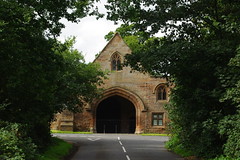
The tree lined avenue ahead serves both a hotel (in the old moated Abbey buildings themselves) and a country park which I believe is owned by Coventry City Council and open to the public for free (except for parking charges). I’ve visited here since childhood and I’ve always liked the avenue of trees lining the entrance drive down to the Abbey. Before the old buildings were renovated and converted into a hotel, the buildings formed the main entrance into the park. Now however, a new route has been constructed leading down to Coombe Pool from a rather incongruous, almost ostentatiouslooking, visitor centre – Personally I don’t think the scale or style fits in with the parkland nor the Abbey in anyway what so ever. From the visitor centre a broad surfaced path leads down to the Pool, crossing a sort of causeway separating the naturalistic lake from the ornamental pond leading up to a moat around the Abbey. 

The causeway is an extremely popular place for feeding the large numbers of ducks, geese and swans and various other water-birds that congregate here and I didn’t linger around the large and rather noisy group of people throwing bread to the birds – instead I headed down the side of the ornamental pond to reach the knot garden in front of the Abbey, where I struggled to keep upright on the very frosty and rather uneven flagged path, taking my life in my hands just for a couple of pic’s – but I was happy with the results!. 


From here I made my way back to the causeway, turned right on a wide path for a very short distance to cross a footbridge and follow the lakeside path for a short way, (just to take some more pic’s) before returning to re-cross the bridge. I turned left away from the noise of the duck-feeders to follow a wide path, sandwiched between a stream (that feeds the lake) and a raised hill topped with some large and impressive redwood trees to reach a toilet block and a smaller lake. After taking a track to the left into the woods, I had to concentrate on finding a path heading north away from Wrautums Field which at times could be glimpsed through the trees. 

I kind of felt a little sad upon exiting the woods as I really like the park, but time stands still for no-one and dusk was drawing in … there wasn’t long before daylight would start disappearing, so I pressed on, rising up through farmland (still on The Centenary Way) on a particularly muddy and slippery path (yuk!) to reach a bridle path on a farm track near Walsgrave Hill Farm. I turned right and now had the opportunity to open my stride again in an attempt to make up some of the time spent dawdling taking pic’s in the park. With the day drawing to a close, the cold had started to descend again and the increased pace certainly helped warm me up a tad, but I did stop briefly in an attempt at some arty photo’s of ice crystal formations in the frozen puddles and again of the sunset reflected in the black plastic wrappings of some hay-bales at Hill Fields Farm.


The track had made a right and left dogs-leg whilst passing through the farm and was now heading eastwards skirting just south of the large Rolls Royce Factory (Ansty works) and emerged onto a minor road (Coombe Fields Road). Here I turned left and then almost immediately right to Follow Peter Hall Lane for a stretch of road walking. Looking back to the west from where I’d come from gave a super view of the sun setting, the cloudless sky a pastel pallet of colours grading through blues to oranges to pinky-red with the remaining semi circle of the sun glowing a pale yellow – Simply beautiful ! 

With the sun going down, light was now going to be limited and I still had some way to go … the best part of two miles or more depending on the choice of route I now had. Rather than take the longer but easiest map reading option of staying on country roads, I decided to take the shorter cross country option, figuring there would be enough dusky light left to finish the walk …. So, immediately after Peter Hall I picked up a clearly visible path heading diagonally across a crop field, which then turned half-left and eventually skirted just north of The Grange to emerge onto the B4029 road. It was getting quite gloomy now and I stepped up the pace again, heading right for a few hundred yards along the road, to reach Walker’s Terrace (a small group of buildings) to leave the road to the left. I picked up a path heading south-east through the middle of a ploughed field to the far corner and then across a grassy field with a series of ridge and furrows (I assume the remnants of ancient allotment farming) to then reach and follow the line of a hedge for another field (now on the Coventry Way) having merged with another path. At the far end of this field the path takes a left turn across a final field to enter Brinklow at the Recreation Grounds and the final rise up to Broad Street via Barr Lane. 

And that, as they say, is that … A super winter’s walk which I thoroughly enjoyed despite the almost excessive pace at the end to finish before I needed to break out my head torch.  

I hope you enjoyed my scribblings ….

T.T.F.N. Gary. 

Next walk/post = Coventry War Memorial Park in the Snow

20091031_Wolston – Ryton – Stretton Circular Walk

20091031_Wolston – Ryton – Stretton Circular Walk

When : 31st October 2009

Who : Just Me

Where : Wolston, Ryton-on-Dunsmore, Stretton-on-Dunsmore and Dunsmore Heath.

Start + End Point : 41,75 Wolston Village

Parking : Residential side-street where I parked as tidily and considerately as possible.

Public Transport : Wolston is on a bus route.

Approx Distance : 9 miles, (15 km)

Significant Heights : Gentle rolling countryside with some rises but generally no more than about 10 metres upwards at any one time and never very steep. The longest single rise however is about 30 metres (approx100 feet) spread over a bit less than a mile (from A45 near Ryton up Knightlow Hill approaching Stretton).

Maps : 1:25,000 OS Explorer Map no. 222, Rugby & Daventry and 1:25,000 OS Explorer Map no. 221, Coventry & Warwick.

Summary : Wolston village, Coventry Way, River Avon, Ryton-on-Dunsmore village, Stretton-on-Dunsmore village, Dunsmore Heath and back to Wolston.

 As I’d walked a section of the “A Coventry Way” from Ryton to Kenilworth earlier in the year (see my earlier posting), I decided to do just a little bit more of the 40-mile round, a short section between Wolston and Ryton and then make a loop back via a different route. Happily the “A Coventry Way Circular Walks“ book, I’d bought a short while before had an ideal solution with a route taking in Stretton-on-Dunsmore and then up and across Dunsmore Heath. This saved me the job of sorting a route out myself but as it happens it’s a fairly obvious circular given there aren’t a huge number of rights of way in the area anyway.

After parking up in Wolston, I headed off to Main Street and the Memorial Cross next to the brook that runs through the village (see my previous 2x recent posts for more about Wolston), from there I quickly found the path I needed – a narrow alleyway alongside the school grounds which brought me out into an area of garages associated with the nearby Manor Estate. This path is used by at least three named ways the “A Coventry Way”, “Shakespeare’s Avon Way” and “Centenary Way”. Instead of the hard surfaces past the garages/estate, you can walk through a narrow strip of woodland instead.

However, just to get a reasonable pace going to start with, I stayed out of the trees and soon reached a line of metal railings (the boundary to The Community and Leisure Centre) and on turning right the path skirted around the outside of the railings, still with the line of woods on my right. A little explore in the woods afforded some gentle views down over fields to the Avon and St. Margaret’s Church. In early spring, clumps of snowdrops and crocus’ emerge from the leaf litter in the trees – really pretty, but obviously no sign could be seen of these with autumn heading into winter.

After a short distance, the wood was left behind; an obvious path stretched out across the field ahead, this made route finding extremely easy aided by a set of circular way-mark disks advertising the previously mentioned “ways” and another one just for good measure saying “public footpath” … Having all four seems just a bit O.T.T. but leaves it in no doubt which way to go!

Carrying on, the path reached and passed alongside a small sewage works which, as is the way with these things, was a bit grotty and I certainly didn’t feel inclined to hang around too long (certainly not a good place for a picnic!) and I pressed on to rejoin more ploughed fields to meet the Avon at one of it’s meanders.  The countryside on the opposite bank was in marked contrast, consisting of the manicured greens, fairways and stands of trees of Brandon Wood Golf Course. Somehow, although being large areas of green space, golf courses seem a little sterile within the “real” countryside where they reside. They almost seem to be plonked down on top of the landscape rather being an integral part of it. This isn’t a criticism, more an observation and I’d certainly prefer this to prairie fields of crops with all hedges ripped up and the like. I wonder how many small dimpled balls are settled in the mud at the bottom of the river? or how many clubs discarded in a fit of anger at a bad shot ?

The route followed around the banks of the Avon for a short while, before cutting across fields, crossing a couple of drainage ditches on footbridges along the way.  The path wasn’t completely obvious here so a bit of map reading was called for, but it didn’t take long to suss out where to go. After crossing one of the ditches, the ground rose up ahead, the route heading roughly southwest whilst the river swung away more northwards towards Brandon Marsh Nature Reserve. The vertical height of the rise ahead was only about 10 metres or so (30 odd feet) but this was enough to make the next decision a little awkward. My compass pointed along the side of a very rough looking hedge, but which side to take ? ….

I choose the left hand side hoping there’d be a way out at the other end and that I wouldn’t have to back-track to this point again.

I needn’t have worried as the hedge turned out to be very badly maintained and large gaps soon appeared, eventually becoming just a wide and very rough “central reservation” running through the large ploughed field. Once again, I was amazed at the different attitude different farmers seem to have. The earlier fields were easy to navigate and cross with paths on the ground; here though, the field was ploughed right up to the headland which was impossible to walk on, forcing me to walk on the newly sprouted crop, the loose tilled soil sinking beneath my feet made progress quite hard work as there was no purchase to push off against. I wasn’t at-all sad when I found the exit from the field to descend a small flight of steps to a tarmac path by the side of the A45 dual carriageway.

It was here that a rather weather-beaten planning application was pinned up; Aggregate Industries UK Ltd. seeking to extract sand and gravel from the site nearby.  This would affect public rights of ways R144, R144c/d/e + f. Representations to the County Council had to be in by 28-Feb-2008 which was some 20 months earlier. [It’s now nearly another year on at time of writing this post and looking at the planning authority’s website it says the application was withdrawn in May 2008]. 

Now, I could have just tried to cross the A45, turn left and continue the walk towards Stretton; but this would have left a very short distance up into Ryton on the Coventry Way not completed. So I turned right rising up towards St. Leonard’s Church which has a super position at the top of the small hill. The A45 splits Ryton-on-Dunsmore in two here and there is a very utilitarian subway to take pedestrians under to the larger part of the village at a small row of shops, including a butchers and post office. I visited the P.O. for some cash and then the butchers for a pasty as a snack – The advantage of walking on a Saturday – and then walked up to outside The Blacksmith Arms (where my previous section of the Coventry way walk started).

It was then I realised I’d no longer got my new sunglasses with me. I quickly revisited the shops; neither place had them! … So I then started back-tracking eyes down to the ground scanning the floor! What a pain!!!! I knew I’d had them with me down by the Avon and now I didn’t – Bother! (or slightly ruder words to that effect). I re-navigated the subway, down the side of the A45 and back up the flight of steps into the ploughed field – where, after reaching the top of the rise, there they were, settled in a shallow furrow by the side of the verge. Relieved but still annoyed at myself I turned around to re-walk the ploughed field for the third time! … I was extra-pleased to re-meet the A45 once again.

I didn’t walk back up into Ryton Village again, instead I found a safe place to cross the dual carriageway – it was reasonably quiet on the road anyway but a speed camera (50mph) and traffic island at least slows the traffic down here. I then crossed the A445 near the large island to head more or less eastwards still alongside the A45 (heading towards Rugby) and after about a couple of hundred yards (at a track to manor farm) I took a path heading up Knightlow Hill, following the line of a hedge for quite some distance on grassy pastures; much nicer walking than the earlier ploughed fields. As my elevation increased some good views back over Coventry and the surrounding countryside opened up before reaching and crossing over Freeboard Lane on the outskirts of Stretton-on-Dunsmore.

Rather than take the path straight on (as suggested in the Coventry Way Circular Walks book), I decided to take the other option here, heading half-right to meet and cross Plott Lane and then walk past some allotments named “The Plot” on my map. Judging by the number and size of his crop, one of the gardeners had had a lot of success growing plastic bottles on canes alongside the path.

At a junction of paths, I took the left turn to follow alongside a sizeable hedge (on my left). On the other side was what looked like a dressage horse training arena and across one side of the arena a row of very large mirrors had been erected attached to a large wooden framework. The mirror wall consisted of several not fully aligned panels which split up and distorted the reflections of the nearby farmhouse and outbuildings. It was really quite disorientating looking into the mirrors. I can imagine it’s caught out quite a few birds as well – I wonder how many have knocked themselves senseless flying into the wall.

The path then led past some farm silos to join Fineacre Lane and I then took the dog leg in the road up towards All Saint’s Church. The lane changes it’s name to Church Hill here and I followed it past the church and down into Stretton Village itself, taking a right hand turn just past the Village Hall to reach and enter The Shoulder of Mutton Inn for a well earned pint of beer. I don’t really know why, but I prefer the Shoulder of Mutton to the villages’ other pub “The Oak and Black Dog” but you’ll need to make your own mind up about the “best one” for you – a good excuse for visiting both hostelries.

Once refreshed, I headed through the pleasant village centre with its stream and small greens, the weak sunshine of the day highlighting the autumn colours all around as I passed the village general store and “The Oak” to head out of the village on Brookside. This reaches the Fosse way (B4453) as a Tee-junction and the route crosses straight over the road to the car park of the recreation ground. A track runs up the left side of the rec’ at the rear of back-gardens to reach farm fields again. After easily navigating these I reached Rugby Lane, turned right for several hundred yards of road walking and then left into a broad and inviting bridle track heading more or less westwards. It was here that I met the only other person, (other than in shops/villages) that I saw all day and we passed the time of day briefly before heading off in opposite directions.


The bridle track lost its double line of hedges to open up onto a farm track heading up the final rise onto Dunsmore Heath at Limekiln Farm, where I turned left onto another farm-track heading northwards. Dunsmore Heath is a misnomer as there isn’t any moorland that the name heath conjures up; the area is almost exclusively farmland.  However there are occasional pools dotted throughout the landscape, little havens for wildlife.

The track led me to again reach the wide A45 dual carriageway which again had to be crossed. There are no speed cameras here and the 60 mph limit is regularly exceeded – excessively so by quite a lot of drivers – Please be extra vigilant and careful when crossing, which has to be done to get back to Wolston.


The route north of the A45 reverted to footpath status rather than bridleway and this led past a couple of attractive tall trees and their long shadows to what should have been two sizeable ponds (at The Holdings) in a stand of trees; but they were almost empty; looking like they’d just been dredged and re-landscaped – The muddy hollows just waiting to fill up with water again.


I guess the area will be really pretty when this process is complete but it more than sufficed as a bit of a refreshment stop before heading out across cow pastures to almost reach the buildings of Manor Farm. Luckily the cows were mainly in adjoining fields, but unluckily their slurry flowing away from the farm made navigating past one corner of the path decidedly awkward – Yuk!

It was now getting quite gloomy as time pressed on making me “get my head down” and pick up the pace to reach Coalpit Lane. A short section of road walking ensued until branching off diagonally left near Hill top Cottage. A few fields later (some ploughed unfortunately) brought me back to The Fosse way which was crossed as carefully as the A45 earlier. The path then climbed Lammas hill before descending into Wolston.

It was on this final section that I had a mini run-in with a dog owner who’s large dog was extremely aggressive to me (stopping short of actually biting me) but made me feel decidedly vulnerable. The owner’s attempts to call the dog back to him several hundred yards away went unheeded for what seemed ages. Eventually the dog was leashed allowing me to finish my walk in peace – Just a shame a good walk was nearly spoilt. I think my heart beat harder at this point than at any other time during the day, as I think my fight or flight adrenaline rush kicked in. I’m afraid I gave the dog-owner a bit of verbal. Why is it that dog owners seem to think everyone likes and gets on with dogs, especially theirs! – The truth is somewhat less than that. Dogs not on leads can be and at times are VERY intimidating! … oh and while I’m on the subject and in rant mode, why do some dog owners pick up their dogs mess in a plastic bag, carefully tie the open end and then instead of taking it home to dispose of, prompty throw it into the branches of trees and hedges and the like ? It’s disgusting! Why, why, why! I just don’t understand it.

Rant over, and walk just about over as well, just the short distance along village roads (Including Dyer’s Lane, School Street and Main Street) in the late afternoon gloom to re-find my car and drive home.

I hope you enjoyed my scribblings ….

Next walks diary = 20090911_High Street Circular Walk (from Brothers Water)

Next post = Midland Hill Walkers Photo links

20091107_A Wander in Wolston

20091107_A Wander in Wolston

When : 7th November 2009

Who : Just Me

Where : Wolston, Warwickshire

Maps : 1:25,000 OS Explorer Map no. 222, Rugby & Daventry.

Grid ref. : 41,75

Significant Heights : Virtually None

Summary : An autumn wander in Wolston, approx mid-way between Coventry and Rugby.

This is just a simple follow on from my last post (A wander by the Avon – Wolston) and as before, I’d dropped my son off at the Leisure and Community Centre in Wolston for an hour long Karate lesson. It was an absolutely stunning autumn morning with not a cloud to be seen and a deep blue sky. It was perfectly still, with a slight chill in the air: the sort of nice chill that makes you feel alive rather than uncomfortably cold! I left the car at the leisure centre having decided there was enough time to walk down into the village and go for a wander around with my camera.

First “port of call” though, was for a coffee from a small take-away sandwich bar (opposite the millennium stone) in Main Street near the central green … I resisted the temptation of a bacon batch (a batch is a bread roll or cob for those not from the Coventry area), which I think was very restrained of me as there’s nothing quite like the smell of bacon cooking to get the appetite going.

According to the Wolston Village website :- “In 1999, a pair of heavy Millstones was recovered from the woods near the old Wolston Mill. Several villagers had suggested that the stones should be used as a feature on the bank of The Brook, something that would act as a link with the village of the past and the village of the new Millennium. Unfortunately one of the stones disintegrated before it could be used, but the remaining stone was safely installed in August 2000. Mrs Kathleen Holloway (nee Lissaman), the oldest Wolstonian at the time, and Mackenzie Newman, the youngest child on the school roll, unveiled the Millstone and plaque on Saturday 30th September 2000, during a special ceremony to mark the event.”

Similar to the nearby Stretton-on-Dunsmore and Princethorpe villages, a brook runs through the middle of Wolston, passing in front of the millstone construction. It is culverted with brickwork banks and has a couple of simple arched bridges giving access to the row of cottages running down to the war memorial cross. My OS map doesn’t give a name to the brook and I haven’t been able to find a name via the World Wide Web either! … Perhaps it hasn’t got a name ? Can anyone tell me otherwise ?

Once past the memorial cross, I branched slightly to the left away from Main Street; the minor road passing through a set of white painted gates (in need of a spruce up) just before the village school. There’s a small path cum alleyway that heads off about here up the side of the school. The “A Coventry Way”, “Centenary Way” and “Shakespeare’s Avon Way” all utilize this path as part of their combined routes on the way to/from Ryton-on-Dunsmore.


Upon passing through the gate, on the right, there’s a meadow, which the brook bisects (but now no longer culverted), with a scattering of mature trees and nearly always a handful of livestock (mostly sheep). The trees were colouring up nicely into their autumn finery; the beech tree nearest the school particularly striking in the morning sun … lovely.

Heading further along the road, on the left, is a small area of woodland with some lonely looking fancy brick gateposts bordering the undergrowth. These were the entrance gates to the old manor, which I believe was demolished in the 1920’s (???). If that is indeed true, the old gate posts have withstood the test of time remarkably well!  A grey squirrel sat for a while as I tried to get close enough to take a photo’ of him/her (my 18-55 lens wouldn’t do all the work for me so I had to do a bit of tip-toe-ing) and I managed a shot, luckily just before it zoomed off high into the tangled web of branches.

The road then led me on to St Margaret’s Church, a rather squat looking building, but attractive none-the-less and with a very rural aspect with the woods, farmland, River Avon and the meadow and brook all around. I’d guess this aspect is unlikely to change as The Avon is Liable to flood here as it has done in the past. In fact a new housing estate (more or less opposite the church on the old Bluemels’ engineering works site) has been designed and constructed with discussion with the environmental Agency. To prevent the estate increasing the risk of flooding, the houses and roads are built on raised areas. The lower areas, including the gardens and central green area have particular rules about leaving a good flow path for any potential flood waters. To this end, things like solid fences, sheds, solid paved patios, etc. are banned from these lower areas. I think the general view is flood risk to the houses is quite low though.

I’ve digressed a tad from my wander. I took the narrow fenced path that heads away from the church to rejoin Main Street, just where the brook feeds into The Avon and where Main Street crosses the old narrow brick-built bridge on its way to Brandon. There’s a set of traffic lights allowing vehicles in only one direction at a time and a separate metal footbridge runs alongside to allow pedestrians to avoid the traffic. On the other side of the Avon are some rather messy looking grassy mounds topped by a small stand of trees and bounded by an ugly rusty fence and ditch. These are the remains of Brandon Castle (dating from medieval times) consisting of a keep and moat. Heading back to the Wolston side of The Avon, I stopped to take in some nice little views of the river. I could have dallied for some time, but the hour to myself was very nearly up and I ended up having to jog most of the way back to The Community Centre to pick up my son and head back home – I don’t “do” jogging or running, preferring to walk for my exercise, but I did manage to be “on-time” for his class ending, albeit a tad out of breath. Maybe I dallied on the bridges above The Avon for a little too long after all, it’s amazing how quickly an hour can disappear!

I hope you enjoyed my scribblings ….

Next Posts :-

Some Information about The Midland Hill Walkers

20091018_Goyt Valley to Peak Forest A-Walk

Midland Hill Walkers Leamington Courier Article

20090906_Ryton to Kenilworth Walk – A Coventry Way

20090906_Ryton to Kenilworth Walk – A Coventry Way

When : 6th September 2009

Who : Just Me

Where : Ryton-on-Dunsmore to Kenilworth.

Map : 1:25,000 OS. Explorer Map No.221, Coventry & Warwickshire.

Start Point : 386,744 [Ryton-on-Dunsmore]

End Point : 285,723 [Abbey Fields, Kenilworth]

Approx Distance : about 11 miles, (17.5 km)

Heights : Hardly worth mentioning really as there wasn’t much in the way of heights climbed. The route is over gently undulating terrain, the biggest climbs being about 20 metres (65 ft) in any one stretch and then only in two or three places.

Summary : Following the route of “A Coventry Way” through Warwickshire Countryside including Ryton-on-Dunsmore, Bubbenhall, Stareton, Stoneleigh, Kenilworth Golf Course, Kenilworth Castle & Abbey Fields Park.

There’s not much of a preamble to this walks post; I just had a little time on this Sunday morning/early afternoon and my good lady wife kindly agreed to drop me off outside The Blacksmiths Arms in Ryton-on-Dunsmore and to pick me up in Kenilworth’s Abbey Fields Park later on, so allowing me to do a linear walk.

Ryton-on-Dunsmore is a kind of an odd place, in that it’s in Warwickshire, but to me feels much more akin to Coventry, which shouldn’t be much of a surprise for a couple of reasons. To start with it’s only about a mile and a half from my home city’s outskirts; if it wasn’t for the floodplain of the River Avon (and I believe protection of green-belt designation), I’m sure they’d have joined up years ago. The other major factor was the large car factory (an industry synonymous with Coventry) just on the outskirts of Ryton. This was recently closed down and has now been levelled, unceremoniously razed to the ground, with just heaps of broken up rubble and acres of bare concrete to mark its former presence. Sadly the long and proud history of car production [Hillman ; Humber ; Rootes ; Chrysler ; Talbot] was finally put to the sword by Peugeot-Citroen when they switched production, to Eastern Europe, in pursuit of a little more profit. That’s enough of that, I think, before I dig a big hole for myself and this diary post becomes a political diatribe … let’s get back to the walk ….

Well, I started just outside The Blacksmith’s Arms (a pub I’ve always liked) on High Street, not far from the A45 dual carriageway and after taking a minute or two to orientate myself-map-to-ground, I headed away from the A45, turned right into a side road and then very soon a left turn to skirt the edge of a sports pitch and the backs of houses eventually reaching the edge of the village. I then turned right to skirt the back of the local school. To my left was a tall wire fence topped by coils of razor wire, behind which was the wasteland of the old car plant; not at all attractive, but striking none-the-less. After a couple of hundred yards or so, the path took a sharp 90-degree turn to the left to head off south-westwards through what would have been the middle of the car plant … why the need for all the razor wire I don’t know, after all there’s absolutely nothing left to steal or damage, save for concrete and scrub.

Carefully crossing the A423 (Oxford Road), I picked up the path again, and although no longer an industrial landscape it still felt rather scratty which was summed up by an extremely smelly and ugly stagnant pond-cum-stream crossed by a footbridge. This little corner certainly would not win any prizes for best beauty spot in Warwickshire. At least three named “ways” :- A Coventry Way, Centenary Way and Shakespeare’s Avon Way, all follow the same route here, I wonder if any of them mention the grottiness of this area. After a biggish dogs-leg in the path, I was hopeful that the path across farmland to Bubbenhall would drastically improve [it couldn’t get much worse] and it did improve but just by a small amount, the walking and map reading was now very easy on a wide farm track, but the terrain was quite boring, not aided I suppose by all the crops having been harvested already and just ploughed fields or rough pasture on either side of me. The only good thing was I could now stretch out my legs and pick up the pace a bit.

I’m not giving a good impression of the walk so far, but it was to improve as I entered Bubbenhall. I stood a while to watch a local football match and after seeing two or three gilt edged scoring opportunities fluffed (really badly fluffed !), I headed into the village. In counterpoint to Ryton, I thought the village had a very Warwickshire feel as I passed grand looking half timbered buildings, a good looking village pub (the Malt Shovel, which I’ve never been in), a square towered stone church (St. Giles’) and horse paddocks and all not far from the banks of the river Avon … lovely …. but it’s not a big place and it’s charms were soon left behind as I again headed out into the fields, still in a roughly south-westerly direction. (ps: I didn’t see the other pub in the village, The Three Horseshoes).

In the next few fields, a series of large modern metal kissing gates have been installed … I think they are designed to maximise accessibility into the countryside for as many people as possible. At a guess, I’d suppose the new gates replaced old stiles. The way marking was good and most remarkably next to a number of the new gates, simple wooden benches had been installed – a very nice touch – and well done to the land-owner for allowing an “opportunity to stop” as well as the legal “right of way”. After a couple of more fields (past Broomhill Farm) the route took a right turn to follow field boundaries to emerge onto a minor road.

Turning left along this minor road marked the beginning of about a mile of road walking and after a couple of hundred yards a T-junction with a slightly larger (and certainly faster road) was reached with the striking building of Tantara Lodge directly opposite. I guess this would have been a gate house entrance to Stoneleigh Deer Park, now surrounded by the fairways of a golf course. To continue the road walking, the route turned left and then right at the next junction … This leads past the sprawl of a business park (sorry, business village) set back from the road, which was once home to offices of Massey-Ferguson Tractors (The main M-F factory was not far away in Tile Hill in Coventry). This was another company synonymous with Coventry and now shut down completely and like “The Peugeot” with production switched abroad – I think it’s a shame not only because of the thousands of jobs lost, but also as I played for the M-F works cricket team for several years.

Not far past the business park, the road reaches the small grouping of houses that make up Stareton itself, blink and you could miss the hamlet, but please don’t, as the route takes a right turn here, leaving the road to head gently down through a strip of woods to cross The River Avon where there was a small clump of geraniums or cranesbill in flower – they were worth a short stop to admire even though I have cultivated varieties in my back garden. Being the end of the season, there hadn’t been much colour in the way of flowers along the way; perhaps enhancing the purple-blue flowers charms beyond what would normally be noticed.

The route then rose roughly northwards on open ground, with a park-land feel, to meet the Stoneleigh Road. There were quite a few people around here, most walking dogs and a lay-by was well frequented by cars, I assume left by the dog walkers. The countryside was much nicer now and after a short walk (northwards) along the road, I crossed to take a path over Motslow hill to pass an old quarry (looking more like an old castle mound to my eyes) and  then picked up a wide sunken path that dropped down to meet the The River Sowe.

There are a number of delightful thatched half-timbered cottages here and I stopped to pass the time of day with a gentleman crossing the footbridge in the opposite direction to me. I mentioned how nice the lobelia flowers were that were planted across the bridge semi-masking some ugly utilitarian piping. It turned out he lives in one of the cottages and the flowers have become a tradition every year since they “dressed” the bridge for their daughter’s wedding to brighten the walk to the nearby church on the opposite bank of the river. A nice story and a lovely touch of public spiritedness … There are still good things happening in our fast paced rat-race of life.

I could have continued on past the village of Stoneleigh, but this is another charming village so rather than pass straight by, I took a small detour along a side road as far as the old smithy, where I found somewhere to rest and have a bite to eat and have an experiment with some odd photo’s of the village … I think they turned out OK … as well as some more conventional views of the village. I then retraced my steps to pick up the path to rise up to meet the B4115, watching a number of dogs undergoing some sort of training as I went … oddly all the parked vehicles were varying sizes of white van. I’ve since been told that the police use this spot for dog training, so maybe that’s what was going on. There now ensued a little more road walking, first turning right alongside the road and then left at a cross roads. There was a narrow strip of rough tarmac path to the side of the road, which meant I didn’t have to brave the cars zipping past still trying to maintain the speed of the A46 they’d probably just left.

After about ½ a mile the aforementioned A46 dual carriageway was reached which I crossed on a major bridge/junction. Immediately after this the path turns left down a field boundary following the line of the slip road heading towards Kingswood Farm. This was made a little awkward by lines of electrified wires forming temporary horse paddocks … These had to be crossed in places, but it does make good map-reading very important as it does feel wrong to do this. I always feel electrified fences shout “keep-out” at me, even though I know I’m on a right of way.

My awkwardness around Kingswood farm was nothing compared to the next “obstacle” to negotiate … Kenilworth Golf Course! … I really dislike crossing golf courses and this was even worse …. there were a couple of fairways to cross (look left and look right signs warning of the potential of flying missiles, I mean golf balls) and then a walk down the length of two fairways within a line of trees separating the two strips of lush grass.


Negotiating past a pond near a putting green, the path then exited the golf course to become a narrow path at the back of some residential gardens. This was quite an unpleasant path, as the golf course fence was at times falling over the path and hedgerow shrubbery/trees were heavily encroaching on the other side of me making progress horrible and I was relieved to emerge onto the residential street of Frythe Close in the Park Hill area of Kenilworth. This soon led to the larger road of Knowle Hill and after turning right down onto the quite sizeable Dalehouse Lane, I then turned right (away from Kenilworth) for about a hundred yards and then left into Common Lane. Rising up here, I soon reached a made-up path heading off into Kenilworth Common following the line of a small stream (Finham Brook). Information boards gave a potted history of the area and what butterflies might be sighted etc. The path went under the broad arches of a railway line and eventually the green corridor ended and I had to pick up side roads, which wasn’t unpleasant as on one side of me was a sizeable area of allotments extending the green feel for a little longer.

Not long afterwards I’d made my way to Abbey fields Park. There are open fields, tennis courts, a small indoor/outdoors swimming pool, kiddies play area and a sizeable pond/small lake with a good number of ducks to feed … Oh and the remains of an Abbey (hence the name) … I was lucky to arrive when one of the better preserved buildings was open with a small history exhibition inside, which I had time to peruse as my family hadn’t arrived yet … for once I’d arrived ahead of our pre-arranged time.

In fact I also had time to :- Take some refreshment ; Walk through to the western end of the park alongside the mini-lake ; Walk around the outside perimeter of the famous castle ; Wander down Castle Green ; Resist the temptation of the Queen & Castle and Clarendon Arms Pub’s and then head back into the park, alongside the other side of the pool to meet my family who’d just arrived.

And that was that, a mixed bag …. a poor start but some nice countryside and it’d stayed dry as well … not bad for 2009 … and 11 miles under my belt … perhaps the start would be better at another time of year rather than at the end of what had been a rather poor summer overall.

I hope you enjoyed my scribblings ….

Next post  = 20090923_Sunset over Cawston-Rugby

20090315_Brinklow Walk Circular

20090315_Brinklow Walk Circular

When : 15th March 2009

Who : Me and Craig

Where : Brinklow, Warwickshire,  England

Maps : 1:25000 Explorer Map no.222, Rugby & Daventry

Start + End Point : 436,796

Approx Distance : 5¾ miles, 9.3 km (per guide book used)

Heights : No significant climbs, Maybe 280 ft (about 85m) uphill over whole walk

Parking : With consideration on Broad Street through Brinklow Village

Public Transport : Yes, believe bus services run to Brinklow from both Rugby and Coventry.

Summary : Brinklow Village ; Coventry Way ; Lovers’ Bridge ; Oxford Canal ; Centenary Way ; M6 ; Stretton Under Fosse ; Newbold Revel College ; Oxford Canal (again) ; Brinklow Motte + Bailey Castle ; Return to Brinklow Village.

I did this walk straight out of a book of local walks that I’d bought a while ago : COUNTRY WALKS IN THE RUGBY AREA, by Jim Watson, published by THISWAY Books. The only deviation I made to Jim’s route was right at the end; where we branched off Ell Street to explore Brinklow’s Motte and Bailey Castle rather than finishing off on the road. Route finding was no problem at-all, as I used both the route description from the book and my 1:25,000 map of the area. It was another lovely spring morning and upon asking my 7 year old, Craig, he was up for a walk with me … nice! … So we quickly got our walking stuff together and set off for the nearby village of Brinklow, sort of mid way between Rugby and Coventry. We found a nice safe parking spot by the side of the very wide and aptly named Broad Street, almost directly opposite The Raven Inn.

We started off wandering up to where a picturesque row of cottages are set back from the main road at The Crescent, overlooked by the Norman church tower raised slightly above us. A classic English village view. Little clumps of daffodils set the scene off perfectly, aided by the bright red traditional telephone box, which was in turn balanced nicely by the equally bright red front door of one of the half-timbered buildings. I particularly liked this building, as the timbers were left a natural wood colour rather than the glossy black paint more often seen. This seemed to fit in with the warm red brick of the building itself.

A family friend some years ago lived in one of the cottages on The Crescent, the small frontage belied the interior which was almost Tardis like, much bigger than imagined with various rooms stretching back away from the road, making the rooms more dark and cosy rather than light and airy.

We returned to and then past the car, and after a bit of map perusing, we turned into Barr lane (it’s not obvious in the guide book that this is indeed right, it just says take an alleyway off Main Street) and we dropped past the village recreation field and small playground, to enter a field, the path heading off diagonally in a westerly direction, Craig (as ever at the start of a walk) out in front at the run. I have no objections to this as it means I can get my legs moving at a nice pace. Turning right after passing through to the next field, Craig continued at the run, enjoying the ups and downs of the ridge and furrow pasture sloping down to the path, whilst I found interest in the dried seed heads in the hedge-row remaining from the winter. We were following paths which have been incorporated into the “A Coventry Way“; a circular route of 40 miles around Coventry and as such the route was way-marked excellently.

http://www.acoventryway.org.uk/

http://www.ldwa.org.uk/ldp/members/show_path.php?path_id=1019

An aside :- Currently, Coventry is politically labelled as being in The West Midlands … an invented district if there ever was one … but in geographical and historical terms, it’s really the major city in Warwickshire. Because of this, much of the “A Coventry Way” is in Warwickshire, as it is here in Brinklow. Unfortunately (in my opinion for what it’s worth) in their county reforms some years ago, Westminster, in their wisdom, decided that as the city was more industrial than rural it ought to be lumped in with the likes of Birmingham, Dudley, Wolverhampton, etc. Now I’ve nothing against those places, but I don’t think Coventry has any real affinity with those places … apart from the A45 and M6, all the roads radiating out from the city head to places like Nuneaton and Bedworth in the north, Kenilworth, Warwick, Royal Leamington Spa and Stratford-Upon-Avon in the South and of course Rugby to the east. One day maybe, Coventry will be ceded back to its traditional roots and become Warwickshire once more … I hope so anyway.

Anyway, back to the walk, after a while of following hedgerows, the path meets a bridle track and then crosses the small and perfectly charming Lover’s Bridge, its two small arches spanning the small stream of Smite Brook. In the sun this was a lovely spot. On the map there’s a non-descript label of FB which has no romance about it at all. Turning the corner brought us onto Smeaton Lane.


Turning left onto this B-road for just 100 yards or so, we then turned right to rise gently up a minor road to Grimes Bridge, where it crosses The Oxford Canal. Instead of crossing immediately, we dropped down the steps to sit and take refreshments by the canal side. I’m sure Craig was grateful for the rest. The Coventry Way heads off here, to follow the tow path, but now refreshed we returned to the road, crossed the bridge and were now following “The Centenary Way” northwards, passing Colehurst Farm and then just after crossing the Rugby to Nuneaton Railway line, Coombe fields Farm. The bridle track was again excellently signed, as we climbed steadily alongside a hedge, at first on its right and later to its left. It became particularly wet in places here, and I resorted to carrying Craig (although he’s getting a bit heavy!) so as to keep his feet dry, as his boots aren’t fully waterproof.

http://www.warwickshire.gov.uk/corporate/chp.nsf/1dcea39eea5f2417802569b900558597/4948768f8d5feeb8802567b000390f6d?OpenDocument

http://www.ldwa.org.uk/ldp/members/show_path.php?path_name=Centenary+Way+(Warwickshire)

We’d now reached quite an elevation, and we could just about make out the Ricoh Arena in the far distance, shining white in the sun. Craig loved this as I’ve introduced him to the trials and tribulations of being a Coventry City supporter … I feel almost guilty as there are probably more bad times than good when it comes to supporting “The City” as a football team … Manchester United, Liverpool or Arsenal they most definitely aren’t! Unfortunately they’re not even in the same class as Wigan or Stoke and the like … quite sad considering how long they’d been in the “top flight” of English football before finally succumbing to Championship level.

Pressing on we came out onto a farm track bridge spanning the M6 and we spent a little while watching the traffic zooming under us in both direction. Craig played the old game of waving to the vehicles as they approached … Some were boring with no reaction, many gave a smile and cheery wave back again and, most notably, several lorry drivers and a couple of coach drivers sounded their horns and/or flashed their lights as they passed underneath … Craig loved that!

Heading back to the southern end of the bridge, we picked up a footpath sloping down at the bottom of the M-way embankment, the roar of the passing traffic slowly lessening as we dropped lower and then branched right to climb up and over a ploughed field to reach a ram shackled barn.


The way then dropped again, now on a rough farm track to a small drainage stream where we stopped for more refreshments. This last section had been a little scratty in places, and a couple of abandoned concrete pipes didn’t really smarten the place up at-all, but Craig did enjoy climbing inside for a while … and then clambering up a pile of old tarmac rubble just opposite.  


The track now climbed to reach The Fosse Way (B4455) which we crossed straight over to then drop towards, and then into, Stretton Under Fosse, a pretty village including half timbered buildings.


A joggle left (along) and then right (over) the B4027 dropped us down a track to the outskirts of Newbold Revel, Prison Officer Training College. I didn’t feel I could take pictures of the facility, given the sensitive nature of security today … the last thing I needed was to be “lifted” under anti-terrorism laws. Having said that, the college is easily found on the interweb, and here’s a couple of links if you want to have a look-see.

http://www.geograph.org.uk/photo/317109

http://www.geograph.org.uk/photo/317115

As we skirted the college grounds, I liked the view over to the right, back towards Stretton, where a couple of lone trees framed the white washed buildings of Tower Cottages. We then soon emerged onto a drive-way right at the main entrance to the college. The path straight over and onwards looks obvious, with good way-marking,  but actually this is a little misleading, as our route turns half right to follow a small stream – Smite Brook – the same as we’d crossed earlier in the day at Lover’s Bridge. This benign little stream had obviously flooded during the winter evidenced by the dead vegetation hanging on some old iron railings along side the watercourse. Thankfully the path winding alongside the stream was now dry and perfectly OK to walk. After a while we followed the stream through a tunnel passing underneath the Rugby-Nuneaton Railway, another focal point on the walk to help keep Craig interested, especially as a Virgin train roared passed.

A short time afterwards we passed through another tunnel, under the Oxford Canal this time, at what are known as Brinklow Arches. We immediately turned completely back on ourselves to climb a set of steps up onto the canal towpath with views back over to the railway and the arch we’d come through a few minutes earlier. Another Virgin train sped past as we watched a barge sedately make its way on the cut. I guess a perfect example of why rail supplanted canals as means to move goods about the country way back when.

Turning right we followed the canal towpath, firstly over a lovely proportioned iron bridge, arching elegantly over a now disused canal branch that used to reach all the way to Brinklow.

After that we had to walk through a long and steep sided cutting to the next bridge in the distance.

The far bank of the cutting is quite unstable and landslides have slipped into the canal bringing trees down with it … I guess the canal here must be quite shallow and difficult to Navigate. Craig by now was flagging a tad and we played word games and were generally silly for a while, but the nicest for me was when we just held hands …. No words, just love.

We left the canal at the road bridge now reached, and walked along the road (westwards) enjoying the site of spring lambs in the fields, until we reached a junction … We took the right turn to steeply climb up Ell Street, a bit of a sting in the tail near the end of the walk and I had to encourage Craig as best I could. Upon reaching the top of the short climb, the expansive views north showed a good proportion of the walk we’d completed.

Another very short distance along the road brought us to an entrance into Brinklow’s Motte and Bailey Castle dating back to Norman times. Quite incredible really to think it’s still there and not been built on. The Motte; the Bailey and the moats are all still evident, and Craig (gaining a spurt of energy) ran to the top of the Motte (the mound) from where we got some brill’ views in all directions. You can see why it was built here, obviously defensible and immediately above the Roman Fosse Way running through the village … I guess in Norman Times the Roman Road would still have been the major roadway of the day.

http://freespace.virgin.net/diane.lindsay/bhg.htm

http://timetrail.warwickshire.gov.uk/detail.aspx?monuid=WA3656

After stopping Craig from running down the Motte, he’d have broken his neck I’m sure because the steepness, we crossed the double Bailey (the courtyards and ramparts/ditches) and outer ditch cum moat to drop down into the village again, almost directly opposite our car.

We headed off home to find the girls of the family … they’d been to Bedworth Civic Hall to support Bilton Silver (Rugby) Band in the Midland Area Brass Band Contest (They came 7th out of 11 in the 2nd section).

That’s about it really, a super local walk with lots of features along the route to keep both a young person (Craig) and an older person (me) interested all the way round.

A final word, I love the high hills and mountains of England and always get excited when a trip further afield is on the horizon (small pun intended, sorry), but this walk proves we should not overlook our local network of paths. Thanks to the likes of Jim’s book and similar publications (and The Ordnance Survey’s maps) there’s no reason not to discover the charms of country walks closer to home.

Cheers for now, Gary … I hope you enjoyed my scribblings ….

Next walk = 20090329_Brailes Walk

20080920_Short walk to the Ricoh


20080920 Sort walk to the Ricoh
When : 20 September 2008
Who : Me and Craig
Where : Coventry, England
Approx distance : A bit of a stroll
Significant height : None
Maps used : None
Parking : Side road off the Foleshill Road
Public Transport : I believe bus routes do exist but we didn’t use them.

 I’m maybe pushing the bounds of credibility here, but it’s a bit of an uphill struggle being a Coventry City supporter sometimes ( I think it’s probably a bit of a struggle being in the team itself or being the manager or anything to do with the club as well a lot of the time). I’m using the uphill bit as an excuse for this rather flippant entry into my country walking blog ! … it also gives a chance to mention Coventry’s Sowe Valley Footpath which might interest someone, although personally I can think of more scenic places to walk.

Still, it’s early in the season and my Son and I were going up to the Ricoh Arena for the first time of the 2008/09 season and hopes were high for a Sky Blues home win against money bags QPR (and ex-city manager Iain Dowie).


We parked-up just off the Foleshill road in a side street (with no parking restrictions) and early enough to avoid having to pay in one of the match-day parking areas. After a short stretch of road walking, we turned into what is labelled “Longford Community Nature Park” … in reality it’s just a sliver of ground that’s been allowed to pretty much grow wild, sandwiched between the Coventry Canal and some houses & industrial units. Still, there are some decent size trees, some reed beds, other undergrowth such as brambles, rose briars and lots of nettles, oh and there’s a little stream.


In fact this little non-descript stream, almost not worth a mention, is the early life of Coventry’s biggest river, The River Sowe, which even at it’s largest (approx 8-10 miles downstream?) is little more than a small tributary of the River Avon. Unfortunately, Coventry isn’t well blessed when it comes to rivers!


An urban greenway walk has been developed called “The Sowe Valley Footpath” and the following are extracts from a web-site that I’ve found that explains and promotes the route :-

“The Sowe Valley is a continuous riverside park stretching for 8½ miles from Hawkesbury Junction Conservation Area (Longford) in the north to Stonebridge Meadows Local Nature Reserve in the south. It links the countryside with the city and passes near to Aldermans Green, Wood End, Bell Green, Henley Green, Walsgrave, Clifford Park, Wyken, Ernesford Grange, Binley, Stoke, Willenhall and Whitley. Its character is constantly changing, some parts are green and rural, others are more built up, but all provide a place of escape from the noise and pressures of the City” ….. “The Sowe Valley is an area of Green Belt, important for its landscape, for quiet recreation, its history, educational and nature conservation value. It is there for you to use, enjoy and treat with respect” ….. “There is plenty to discover in the Sowe Valley. A riverside footpath runs along the length of the Valley to help you enjoy it and there are information panels at key sites” ….. “The Sowe Valley has a long history of farming, with crops such as wheat, rye, peas and oats being grown. As industries such as coal mining increased, the working farm became a thing of the past. Today Henley Mill Farm is one of only two traditional working farms now remaining in Sowe Valley” ….. “At Hawkesbury Junction the footpath links into The Centenary Way, the Oxford Canal Walk and the Coventry Canal Art Trail, which gives an opportunity for future interesting walks.”

http://www.coventry-walks.org.uk/booklets/sowe-valley/svf.html

http://www.ramblers.org.uk/info/paths/centenaryWarwickshire.html

http://www2.coventry.gov.uk/canalarttrail/map.html

http://www.ramblers.org.uk/info/paths/oxfordcanal.html

Anyway, that’s, by the by really, as our very little walk went through the nature reserve, crossing “The Sowe” by means of a metal footbridge; then up a rise to cross over the Coventry Canal, on a brick built bridge, from where you can see newly built flats over-looking the cut in a modern take on urban living.

Soon afterwards we crossed over the Coventry to Nuneaton railway line by means of a modern and pretty-ugly metal brige construction. [ Don’t you love the English language, how can you have a pretty-ugly anything, isn’t that a contradiction in terms?, but I guess you all know what I mean ].

Once over the railway we emerged into the car parking areas of the home of Coventry City Football Club … The Ricoh Arena … a very new and modern stadium that is very different from the old Highfield road site.


There were hardly any other fans making their way as we went, but I put that down to being a tad early, but it was very quiet outside the stadium as well and with about 1/2 hour to kick off that didn’t bode well for a good crowd …. it turned out the official gate was published at 16,718 … making the ground only about 1/2 full.

  • perhaps the credit crunch is biting deep into peoples pockets ?
  • perhaps the long suffering fans of CCFC need some good, entertaining and winning football to watch before the crowds start flooding back again ?
  • perhaps the stupid cashless payment system inside the stadium, for a drink or a pie or whatever, is putting people off (just another way to rip us off, I and others think?) …. it certainly stopped me buying a pint for me and a cola for my son.
  • perhaps after such a poor summer, people were just out and about doing other things in the sunshine – we havn’t seen too much of it this year really have we?

http://www.ccfc.premiumtv.co.uk/page/Home/

http://www.ricoharena.com/

One point that’s just got to be made :- The railway passes only a matter of yards from the stadium, but there still isn’t a station provided for match-day supporters (or concert goers when the stadium is given over to the likes of Rod Stewart, Bryan Adams, etc.) … in this day-and-age of so called integrated public transport and green politics you’d have thought this would be an obvious solution to move lots of people in and out quickly and efficiently, but it seems not in Coventry …

perhaps if we were in an East-end suburb of London we’d have overground and underground train links; a mono-rail; trams; multiple bus routes; a handful of bicycle lanes and maybe even a ski-lift by now ….

but no, Coventry isn’t particularly fashionable and it isn’t hosting the 2012 games, so I can’t see any funds coming our way … Network rail and central government need to get their act into gear and support cities not in the south-east corner of England !!! If you agree don’t lobby me, lobby your MP !!! Sorry, soap box moment and moan over …


Anyway, the route back after the match was much slower, as there was a real “log-jam” as hundreds of people tried to squeeze across both the railway and canal bridges … the main reason for the slow progress, was at the canal bridge, where some anti-bike barriers were only allowing one, maybe two people through at a time. Still it was all good humoured (helped by the decent weather) and fans all around chatted about the game whilst patiently waiting for the queue to shuffle forwards.

Once back into the “nature reserve” we branched off from the main flow of the crowd and jogged back to the Foleshill Road and thence on to the car along the road. I know it’s only a footy match, but your team winning does bring a bounce to your step.

Oh, if you’re interested the match ended Cov’ City-1, Queens Park Rangers-0 … Hurray !

End of an odd post, but hey, it was a walk … of sorts … well almost !

Next walk … maybe the Malvern Hills next week-end … A proper place to walk.
T.T.F.N.